

MOROTAI - A number of residents in Morotai Island Regency, North Maluku (Malut) started their normal activities after being rocked by a tectonic earthquake with a magnitude of 6.8 on Friday, February 24 in the morning at around 05.02 WIT.
One of the residents of Morotai, Ahmad Kadri, said residents on Morotai Island have been carrying out activities, despite an earthquake with a magnitude of 6.8.
"Indeed, this morning residents panicked when an earthquake rocked Morotai, but currently residents' activities remain normal," he said when contacted by ANTARA from Ternate, Friday afternoon.
Based on information from the Regional Disaster Management Agency (BPBD) of Morotai Island Regency, his party has appealed to the public to remain calm and not be influenced by issues that cannot be justified.
In addition, avoiding buildings that are cracked or damaged by the earthquake. Check and make sure the building where you live is earthquake-resistant enough, or there is no damage caused by earthquake vibrations that endanger the stability of the building before you return to the house.
Contacted separately, the Head of Ternate Geophysics Station Andri Wijaya stated that the M 6.8 earthquake on Morotai Island on Friday did not have the potential for a tsunami. The earthquake that occurred on Morotai Island was due to subduction activity of the Philippine Sea plate, so people in the area were asked to remain calm and alert, because the earthquake did not have the potential for a tsunami.
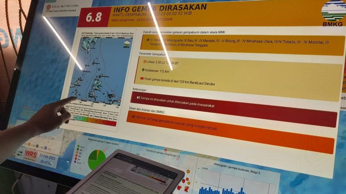
"The earthquake had a magnitude of six coma eight which rocked the district of Morotai Island at coordinates three point 31 north and 128 coma zero six east longitude or a distance of 142 kilometers with a depth of 107 kilometers," he said.
Meanwhile, according to the results of the BMKG analysis, this earthquake has updated parameters with a magnitude of M6.5. The epicenter of the earthquake is precisely located in the sea at a distance of 142 km northwest of Daruba City, Morotai Island, North Maluku at a depth of 107 km.
Taking into account the location of the epicenter and the depth of the hypocenter, the earthquake that occurred was a medium earthquake due to subduction activity of the Philippine sea plate.
"The results of the analysis of the source mechanism show that the earthquake has an upward sliding mechanism," he said.
This earthquake had an impact and was felt in Tahuna, Melonguane, Siau areas with an intensity scale of IV MMI and if during the day it was felt by many people in houses, the areas of Manado, Bitung, North Minahasa, Tobelo, Morotai with an intensity scale of III-IV MMI, namely the vibration felt real in the house as if a truck was passing, the Tondano, Tomohon, Southeast Minahasa area with an intensity scale of III MMI.
The English, Chinese, Japanese, Arabic, and French versions are automatically generated by the AI. So there may still be inaccuracies in translating, please always see Indonesian as our main language. (system supported by DigitalSiber.id)
Add VOI as a Preferred Source
Follow VOI news updates across Google.
+


