JAKARTA - Acting Head of the Earthquake and Tsunami Center of the Meteorology, Climatology and Geophysics Agency (BMKG) Daryono said the earthquake with a magnitude of 5.6 (updated from 5.8) that occurred in the south coast of Klungkung, Bali, was classified as a medium earthquake. .
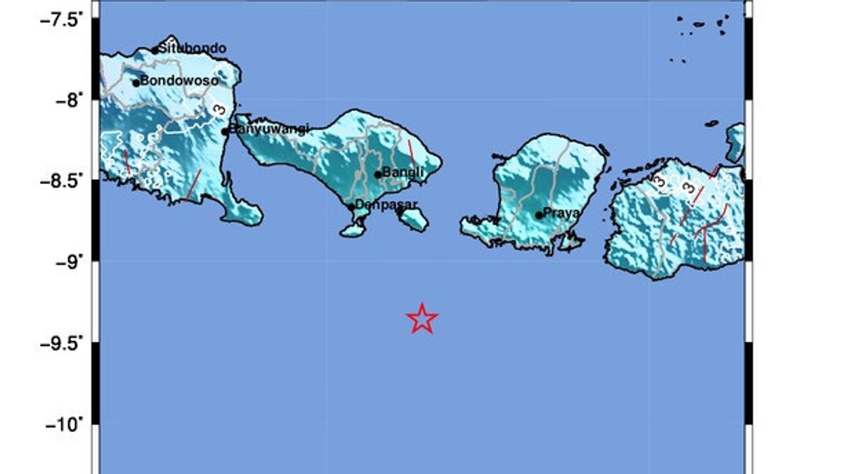
According to him, the earthquake whose center was in the sea at a depth of 134 km at coordinates 9.36 degrees south latitude and 115.56 degrees east longitude, approximately 47 mm south of Nusa Penida, Klungkung Regency, occurred due to plate subduction activity.
"The results of the analysis of the source mechanism show that the earthquake has an upward movement mechanism," he said as quoted in a written statement quoted by ANTARA, Monday, August 22.
According to BMKG data, the earthquake was felt in the areas of Badung, Denpasar, Klungkung, Mataram, West Lombok, and Central Lombok on a scale of IV MMI.
In addition, the impact of the earthquake was felt in the areas of Buleleng, Tabanan, Karangasem, Gianyar, North Lombok, East Lombok, Dompu, Sumbawa, West Sumbawa, and Bima on the MMI III intensity scale.
In the Jember area, the vibrations caused by the earthquake were felt on the MMI II intensity scale.
According to the modeling results, the earthquake that occurred in the south coast of Klungkung did not have the potential to cause a tsunami.
"As of 16.00 WIB, the results of BMKG monitoring have not shown any aftershocks," said Daryono.
The BMKG appealed to residents to avoid buildings that were cracked or damaged by the earthquake and to ensure that residential buildings were earthquake-resistant and did not suffer damage that could endanger the stability of the building before returning to their homes.
The English, Chinese, Japanese, Arabic, and French versions are automatically generated by the AI. So there may still be inaccuracies in translating, please always see Indonesian as our main language. (system supported by DigitalSiber.id)
