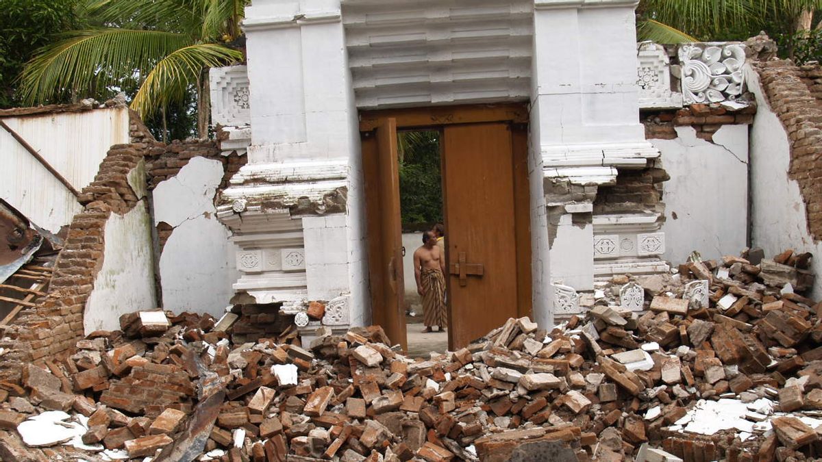
JAKARTA - On 27 May 2006 an earthquake measuring 5.9 on the Richter scale rocked Yogyakarta and its surroundings. The earthquake occurred at around 05.53 WIB, when many people were still sleeping.
The strength of the earthquake even destroyed various buildings, infrastructure, and electricity and telecommunication networks throughout Yogyakarta, Bantul, and surrounding areas. Tourist attractions such as Prambanan Temple and Imogiri Tomb were also reported to have been affected by the earthquake.
Meanwhile, victims of this natural disaster were in various areas such as Sleman, Kulon Progo, Gunung Kidul, Klaten, and Boyolali. When the earthquake occurred, the people of Yogyakarta were also afraid of the occurrence of wedhus gembel and lava from the eruption of Merapi.
The earthquake that rocked occurred from the sea. The 2006 Yogyakarta earthquake was the second largest natural disaster after the earthquake and tsunami in Aceh which occurred in 2004.

Quoting the Kompas report, there were 3,098 victims who were killed and 2,971 of them came from Bantul Regency on Saturday 27 May 2006 until 00.15 WIB. The total casualties were around 6,000 people.
The death toll was due to collapsed buildings and injuries due to the extraordinary panic. According to the Geophysics Station of the Yogyakarta Meteorology and Geophysics Agency (BMG) the earthquake occurred off the coast of the Indian Ocean.
The epicenter position is at the coordinates of 8.26 South Latitude and 110.33 East Longitude, or at a distance of 38 kilometers south of Yogyakarta at a depth of 33 kilometers. The earthquake occurred due to a collision between the Indo-Australian Plate and the Eurasian Plate, at a distance of about 150 km-180 kilometers to the south of the coastline of Java Island.
After the big earthquake, there were small aftershocks that occurred continuously. According to Tony Agus Wijaya, a geophysical observer at the Yogyakarta Geophysics Station, the strength of the earthquake did not cause a tsunami wave.
The impact of the Yogyakarta earthquake
On June 13, 2006, the government said that the Yogyakarta and Central Java earthquakes caused a loss of Rp. 29.2 trillion. This was conveyed directly by the Minister of National Development Planning / Head of Bappenas at that time, Paskah Suzetta.
According to Paskah, the houses were totally destroyed as many as 400 thousand units. Meanwhile, 200 thousand houses were seriously damaged.
He also said the impact of the earthquake had already been exposed to countries that had committed to providing assistance, including the ADB and the World Bank. In addition, another impact of the earthquake was that there were 1.2 million people living in Yogyakarta who lost their homes.
It is known that this number is higher than the number of victims who lost their homes due to the tsunami in Aceh and Sri Lanka. This is confirmed by the leader of Care International Germany Dr. Wolfgang Jamann.

"Indeed, the effort to help themselves in Indonesia is very large, so it does not only depend on foreign aid. But so that people in Indonesia can help themselves, materials and instructions are needed. People need medicines and some also need counseling. We also don't want people to build houses in such a way that in case of another earthquake, they will be destroyed again, "said Jamann, quoted from DW.
Indeed, many countries have extended assistance, even directly coming to Yogyakarta. Countries such as China, Singapore and Taiwan have established coordination posts in Bantul with different priorities. Meanwhile, helicopters carrying humanitarian aid also continued to arrive.
At that time, Minister of Finance Sri Mulyani Indrawati said foreign aid for earthquake victims in Yogyakarta would be managed by forming a special unit. Assistance is expected to be given right on target and according to the most urgent needs. The priorities for aid flows are in the education, transportation, health and energy sectors.
Construction of the Inscription MonumentTo commemorate this earthquake, the Provincial Government of the Special Region of Yogyakarta built a monument or perch. The monument is located above the Opak Fault, which is a fault around the Opak River, a river that starts at Mount Merapi, then flows south with its estuary facing directly into the Indian Ocean on Samas Beach.
The memorial is built from Merapi andesite stones as high as 1.5 meters. On the left, right, and front there is an inscription signed by Yogyakarta Governor Sri Sultan Hamengkubuwono X, Chancellor of UPN Veteran, and Regent of Bantul Suharsono. The construction of the monument was financed with assistance from the head of the BPBD Bantul, UPN, and the local community.
* Read other information about NATURAL DISASTERS or read other interesting writings from Putri Ainur Islam.
TODAY'S HISTORY OthersThe English, Chinese, Japanese, Arabic, and French versions are automatically generated by the AI. So there may still be inaccuracies in translating, please always see Indonesian as our main language. (system supported by DigitalSiber.id)


