

JAKARTA Disasters that occurred in North Sumatra, West Sumatra, and Aceh sparked discussions about the causes of successive disasters in the region. Extreme weather and massive deforestation are a combination that causes storms in Sumatra.
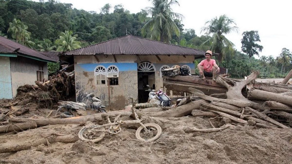
Sumatra is grieving. Heavy rains that have occurred over the past few days have caused floods and landslides in dozens of regencies and cities in North Sumatra, West Sumatra, and Aceh. Tens of thousands of residents were affected and others reported to have died.
Regarding the disaster in Sumatra, the National Search and Rescue Agency (Basarnas) released, until Friday (28/11/2025), as many as 105 people died.
This number, with details in North Sumatra, recorded 83 people died and 81 people are still being searched. Most of the victims who died were in Central Tapanuli, which was 34 people, while in Sibolga 30 people. A total of 677 people were successfully evacuated.
Records in West Sumatra say 22 people died and 12 people are still being sought. Data from the Padang SAR Office stated that the highest number of victims died were in Agam, which was 10 people. The total evacuated residents reached 29,152 people.
In Aceh, the death and disappearance victims are still being recorded. According to Banda Aceh SAR data, as many as 645 people have been evacuated. Most of the investigators are in North Aceh, namely 3,507 people, and East Aceh 2,456 people.
Disasters in Sumtra have attracted the attention of netizens. The hashtag #PrayForSumatera echoed on social media. In the midst of this sad atmosphere, the public is wondering what exactly caused the flash floods and landslides in a number of areas of Sumatra?
The Meteorology, Climatology and Geophysics Agency (BMKG) said that heavy rains that caused large floods and landslides in many areas were caused by Cyclone Senyar.
Researcher from the BRIN Center for Climate and Atmospheric Research Erma Yulihastin said Cyclone Senyar was a very influential natural factor causing extreme rain in North Sumatra, West Sumatra, and Aceh, which triggered various disasters.
Erma said, this cyclone triggered the formation of a Meso-scale Convective Complex or a collection of massive rain cloud clusters that resulted in continuous rain and strong winds. This can be seen from the record of high daily rainfall on the west coast of Sumatra on November 23-24.
Cyclone Senyar is said to be an important factor that caused a series of disasters in Aceh, North Sumatra, and West Sumatra. However, a number of observers and environmental activists said that massive forest development and logging also exacerbated the effects of extreme rain and strong winds.
SEE ALSO:
-
 | BERNAS
Mengapa Baju Merek Lokal Sulit Bersaing dengan Pakaian Bekas Impor?
27 November 2025, 07:00 -
 | BERNAS
Nilai Matematika Jeblok dalam TKA 2025 Merupakan Sinyal Krisis Struktural
26 November 2025, 09:30


In a broadcast that was spread on social media, logs were seen being dragged along by the flood. Warganet also linked this to the recent loss of forests in Sumatra as a supporter of floods and landslides in the Sumatra region.
According to Global Forest Watch (GFW) data, in the 2001-2024 period Aceh lost 860 thousand tree covers, or the equivalent of 17 percent of the tree cover area in 2000.
Still referring to GFW data, From 2001 to 2024, North Sumatra lost 1.6 million tree cover or the equivalent of 28 percent of the total tree cover area in 2000. The figure is tandem with tree cover obtained in 2000-2020, which is 390 thousand ha. The same thing happened in West Sumatra. They lost 740,000 tree cover in the 2001-2024 period, equivalent to 19 percent of the total tree cover in 2000.
North Sumatra WALHI Advocacy and Campaign Manager Jaka Damanik highlighted the activities of the extractive industry as the cause of the massive impact of heavy rains this time.
Jaka said that the Batang Toru ecosystem, which is part of the tropical forest that stretches from North Tapanuli to South Tapanuli, is now controlled by many mining, plantation, and energy companies. These three areas were severely affected when heavy rains and strong winds occurred due to the Senyar cyclone arriving.
"The government must evaluate the company's permits operating in the Batang Toru ecosystem. It must be evaluated, at least don't expand," said Jaka.
Based on WALHI North Sumatra records, the Batang Toru ecosystem is around 250,000 ha, but in the last five years "experiencing deforestation has reached 30 percent."
"Now the logic is economiclogic. We hope that pro-environmental policies can be implemented properly by the government," explained Jaka.
The existence of heavy rain and climate cycles will certainly have an impact on floods and landslides in a number of areas of North Sumatra, West Sumatra, and Aceh. However, it is undeniable that deforestation that continues to accumulate has caused forests to lose their absorption.
Forest Watch Indonesia (FWI) Research and Data Manager Ogy Dwi Aulia explained how the combination of heavy rain and deforestation phenomena in Sumatra became a time bomb.
Deforestation that has occurred over the years, said Ogy, has reduced the water capacity. So, when it rains heavily due to cyclones, the forest loses its ability to carry out its ecological function.
Hutan not only binds water, but also binds soil in an area. When deforestation occurs, there are no more water binders there, causing the soil to be easily eroded, the process of erosion, causing landslides, and so on. Flash floods are also triggered because of this, because there is no more ability," said Ogy explaining.
The English, Chinese, Japanese, Arabic, and French versions are automatically generated by the AI. So there may still be inaccuracies in translating, please always see Indonesian as our main language. (system supported by DigitalSiber.id)
Most Popular Tags
#Prabowo Subianto #donald trump #Febrie Adriansyah #8791 #giias 2026Popular


