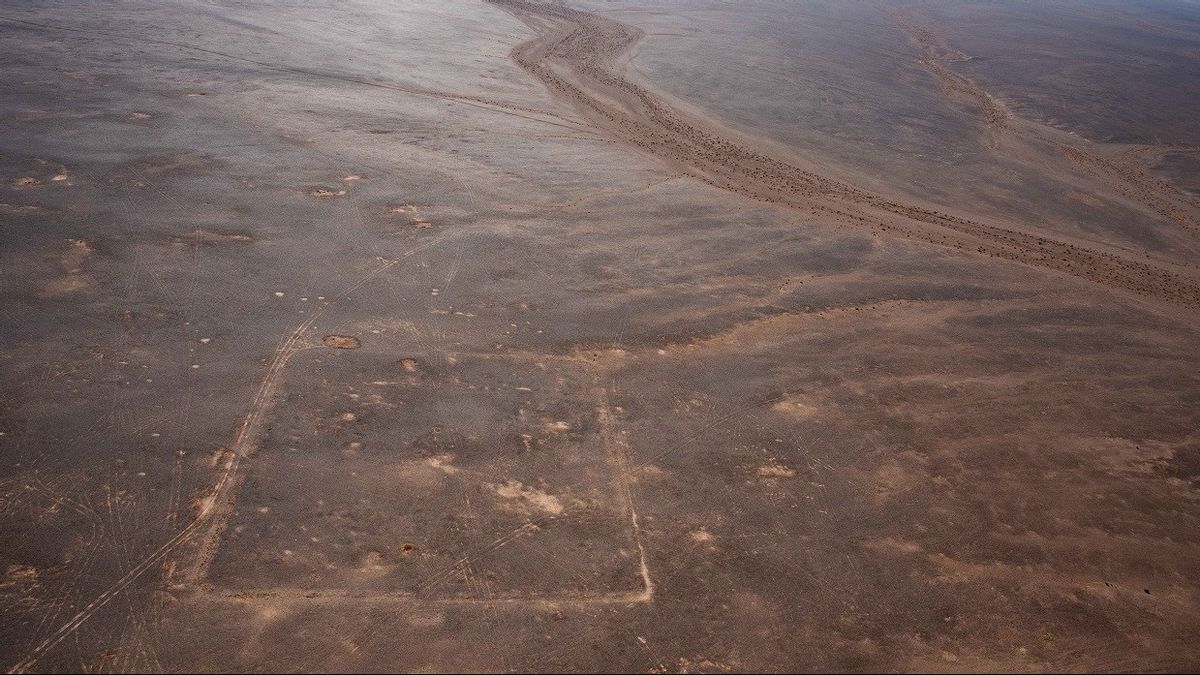


Satellite images have uncovered the discovery of a "spectacular" of a Roman military camp in the Arab Desert, when archaeologists from the University of Oxford identified three new Roman camps - in "typical brake cards" - in northern Arabia.
The discovery supports the idea of a sudden attack during a previously undiscovered Roman military campaign related to the takeover of the Kingdom of Nagaean in 106 AD, a civilization centered around the city of Petra in modern Jordan.
Michael Fradley, who led the research and first identified well-maintained camps through Google Earth, said there was little doubt about the date of the construction of the camps.
"We are almost sure that the camps were built by the Roman army, given the distinctive shape of the playing cards from these cages with opposite entrances on each side," he said in a report published in the journal 'Antiquity', as reported by The National News April 27.
"The only striking difference between the two is that the westernmost camp is much bigger than the two camps to the east."
Meanwhile, Oxford Roman military expert Mike Bishop said: "These camps are spectacular new discoveries and important new insights into the Roman campaign in Arabia".
"The Roman strongholds and strongholds show how the Romans controlled a province. But the camps temporarily revealed how they got it at first," he explained.
The researchers suspect that the camps were built by the army as temporary shelters that can be maintained and used when they are campaigning.
"The level of preservation of these camps is extraordinary, especially as they may only be used in days or weeks," added Dr. Fradley.
"They follow the suburban charter route connecting Bayir and Dumat Al Janadal. This shows a strategy to cut more frequently used routes in Wadi Sirhan, adding a surprise element to the attack," he explained.
"It's amazing that we can see this moment in time played on the landscape scale," he said.
As for Andrew Wilson, one of the authors of the paper, said: "These camps are marching - if we are right in determining the date in the early second century - it shows that Roman annexation of the Kingdom of Nabataean after the death of the last king, Rabbel II Soter in 106 AD, is not an easy matter and that Rome is moving quickly to secure the kingdom."
Since the distance between each camp was 37 km to 44 km, the researchers speculated that the distance was too far to be crossed by infantry forces in a day.
Therefore, they suspect that the camps were built by army units that could traverse barren terrain in one day, perhaps riding a camel.
Based on the distance between the camps, there are also estimates, other camps may lie further west in the Umayyah fort and the well station in the Bayir.
This study determined that the newly discovered camps were walking in a straight line to Dumat Al Janadal in what is now Saudi Arabia, but at that time it was a settlement to the east of the Kingdom of Nabatea.
The researchers say these findings suggest that Roma must force a takeover. While the existing Roman history states that the transfer of power was a peaceful event at the end of the reign of the last Nabataean king.
Archaeologists still need to confirm the date of the camps through field investigations, but there are other questions that need to be answered.
"Why does the western camp have twice the capacity of the other two camps? Are the troops divided, and if so, where did the other half go?" asked Dr. Wilson.
"Has half of them destroyed in combat, or are they still in the west camp to supply water to other camps?" he concluded.
The English, Chinese, Japanese, Arabic, and French versions are automatically generated by the AI. So there may still be inaccuracies in translating, please always see Indonesian as our main language. (system supported by DigitalSiber.id)