

JAKARTA - The Meteorology, Climatology and Geophysics Agency (BMKG) reported that a tsunami of the Mentawai-Siberut magnitude earthquake was observed as high as 11 Centimeters (CM) on Tuesday morning.
"Tsunami was observed 11 cm, from the data on the gauge at the Tanah Bala Nias Selatan Station," said Head of the BMKG Earthquake and Tsunami Center Daryono in Jakarta.
The current earthquake strength has been updated to a magnitude of 6.9. Daryono revealed that the earthquake was a megathrust event.
The earthquake was felt in Siberut, Mentawai VI MMI, West Pasaman, Padang Pariaman, Agam, Padang V MMI, Gunung Sitoli, Padang Panjang, Pesisir Selatan, Fifty Cities, South Solok, Solok, Bukittinggi, Padang Sidempuan III MMI, Labuhan Batu Bengkalis II MMI.
관련 항목:
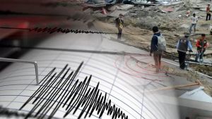

BMKG issued a tsunami early warning for North Sumatra, after the 7.3 magnitude earthquake (M) on Tuesday at 03.00 WIB.
The epicenter of the earthquake was at 0.93 South Latitude, 98.39 East Longitude, 177 km northwest of the Mentawai Islands, West Sumatra with a depth of 84 km.
BMKG appealed to be vigilant for the Tanabala Island area, South Nias Regency, North Sumatra. Wave arrival times can be different. The first wave could not be the largest.
The English, Chinese, Japanese, Arabic, and French versions are automatically generated by the AI. So there may still be inaccuracies in translating, please always see Indonesian as our main language. (system supported by DigitalSiber.id)