

JAKARTA - The Geological Agency of the Ministry of Energy and Mineral Resources (ESDM), in addition to carrying out investigations and services in the field of ESDM, also carries out disaster mitigation activities.
In the first six months of 2022, the Geological Agency has provided various recommendations to local governments regarding potential disasters, including volcanic eruptions, ground movements, earthquakes, and tsunamis.
Secretary of the Geological Agency, Ediar Usman, said the Geological Agency carried out visual and instrumental monitoring of volcanic eruptions and ground movements.
Meanwhile, for the potential for earthquakes and tsunamis, the Geological Agency cooperates with the Meteorology, Climatology and Geophysics Agency (MBKG) in conducting geological analysis and mitigation.
"All data related to geological evaluation and monitoring of potential volcanic eruptions and ground movements are submitted directly to the regional government and also other relevant parties in the region. Furthermore, these data can be submitted to the local community," said Ediar at the Geological Disaster Information Press Conference. Semester I Year 2022 online, Thursday 4 August.
Similarly, the Head of the Center for Volcanology and Geological Hazard Mitigation, Hendra Gunawan, said that the information provided by the Geological Agency to the Regional Government is a recommendation.
"The Geological Agency always provides recommendations to all regions in Indonesia. We provide a map of the potential for ground movement, namely which areas have the potential for landslides to occur in the future. At the beginning of the month, recommendations are always sent. The Geological Agency also provides recommendations regarding relocation sites and technical advice to the Regional Government in the event of a ground movement," continued Hendra.
Hendra also appealed to the Regional Government to always follow the recommendations given by the Geological Agency, so that geological disaster mitigation measures can run optimally and minimize the loss of life and property.
"The geological agency will continue to coordinate with the National Disaster Management Agency (BNPB) and the Regional Disaster Management Agency (BPBD) because disaster management cannot be done alone," he said.
In addition, coordination is also carried out with the BMKG in handling the mitigation of ground movements as well as earthquakes and tsunamis, for which we need secondary data from the BMKG and the National Research Agency (BRIN).
"We hope that the cooperation will go well, thus avoiding casualties and anticipating potential areas," said Hendra.
In the period from January to June 2022, there were 9 volcanoes that erupted, both explosively and effusively, namely: Volcanoes Dempo, Merapi, Semeru, Anak Krakatau, Ili Lewotolok, Soputan, Karangetang, Ibu, and Dukono. There are 2 volcanoes whose eruptions are accompanied by hot clouds, and 3 volcanoes whose activities are accompanied by lava avalanches.
Currently, there are 5 volcanoes with an activity level of Level III or SIAGA, namely: Anak Krakatau, Merapi, Semeru, Ili Lewotolok and Awu; 15 volcanoes at Level II or Alert; and 48 volcanoes at Level I or Normal.
And in addition, on July 28, 2022, the activity level of Mount Raung in East Java Province rose to Level II (Alert).
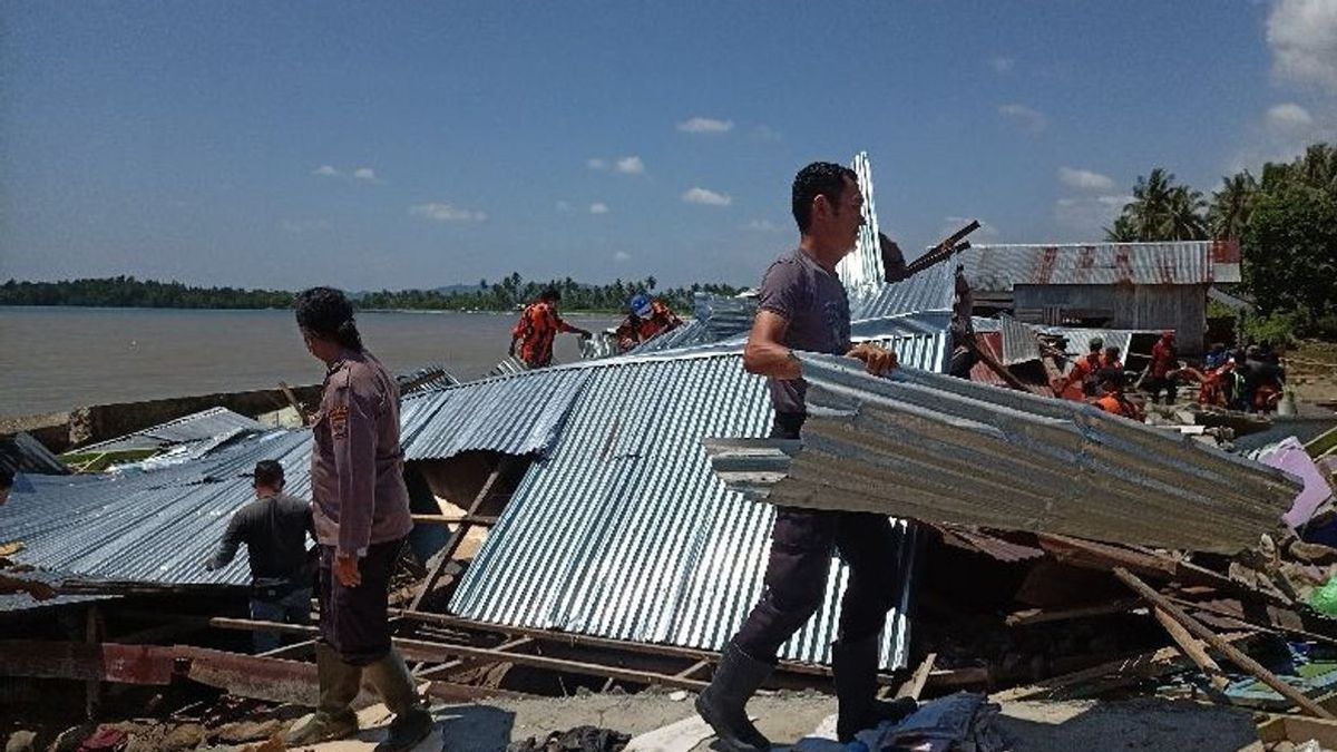
In addition, there have been 10 destructive earthquakes, namely in Tobelo, Pandeglang, Kep. Talaud, West Pasaman, Sukabumi, West Seram, Kendari, North Halmahera, Southwest Maluku, and Mamuju.
As a mitigation effort, the Geological Agency has carried out emergency response activities or rapid assessments to map and analyze the impact of earthquakes and provide technical recommendations for earthquake disaster mitigation.
In addition to earthquakes, from January to June 2022 throughout Indonesia there have been 318 ground motion events.
Land movement is the most frequent geological disaster in Indonesia, especially in the rainy season.
To mitigate geological disasters, during the first six months of 2022, the Geological Agency has carried out various activities related to geological disaster mitigation efforts.
In addition to monitoring volcanoes, 13 Emergency Response activities have been carried out, mapping of 1 Map of Volcanic Disaster Prone Areas (KRB), mapping of 2 Geological Maps of Volcanoes, and 2 revisions of Volcano KRB Maps.
A total of 33 recommendations related to above normal volcanic activity, 307 VONA, 2 installations of volcanic monitoring equipment, and 3 optimization of volcanic monitoring equipment.
In earthquake and tsunami mitigation, 2 emergency response activities, 7 post-disaster activities, 2 Earthquake Microzonation investigations, mapping of 1 Earthquake Hazard-Prone Area Map (KRB), mapping of 1 Tsunami KRB Map, 1 socialization activity, 1 optimization of fault monitoring equipment active, and 22 recommendations.
Hendra added that this geological disaster mitigation effort is useful for providing direction to the Regional Government and providing certainty regarding the follow-up of Regional Government policies in providing disaster services.
In addition, there are recommendations for rebuilding disaster areas and post-disaster relocation areas.
"PVMBG also continues to provide assistance in the preparation of contingency plans, education to the public, as well as the preparation of policies related to spatial planning, risk maps, etc. The benefits of geological disaster mitigation will be increasingly felt by strengthening networks between related ministries and institutions, as well as local government," concluded Hendra.
The English, Chinese, Japanese, Arabic, and French versions are automatically generated by the AI. So there may still be inaccuracies in translating, please always see Indonesian as our main language. (system supported by DigitalSiber.id)