

JAKARTA - The Cianjur earthquake, Monday, November 21, could be said to be not an earthquake with a very large force. Especially when compared to the devastating earthquakes that have occurred in recent years.
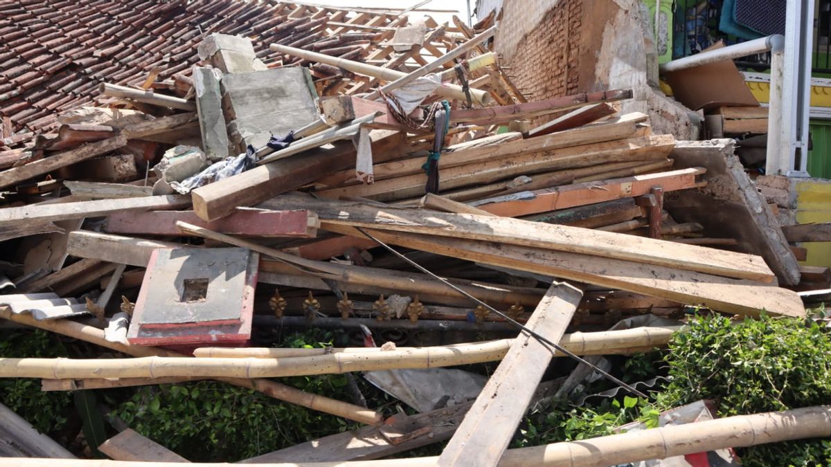
However, the earthquake with a magnitude of 5.6 caused quite a damage to the residents of Cianjur and its surroundings.
The earthquake on Monday, at 13.21 WIB, to be precise, claimed 103 people. The Sukabumi Regional Disaster Management Agency (BPBD) also revealed hundreds of houses were heavily damaged.
There are several reasons why there were quite a lot of casualties. For example, because the soil in the Cianjur earthquake area is prone to shocks. The settlements or houses built are mostly earthquake-resistant. The combination is suspected to have caused a lot of damage and casualties.
Warga meninggal dunia pasca gempa bumi di Kabupaten Cianjur, Provinsi Jawa Barat masih terus bertambah. Data per Selasa (22/11) pukul 09.55 WIB dilaporkan 103 orang meninggal dunia.#GempaBumi #GempaCianjur #BNPBIndonesia pic.twitter.com/6Ok3Aly0EM
— BNPB Indonesia (@BNPB_Indonesia) November 22, 2022
In addition, according to information from the Meteorology, Climatology and Geophysics Agency (BMKG), the earthquake with a magnitude of 5.6 was located on land at coordinates 107.05 East Longitude and 6.84 South Latitude, about 9.65 km southwest of Cianjur City or 16.8 km northeast of Sukabumi City, precisely on land in the Sukalarang region, at a depth of 11 km, which is quite shallow.
According to BMKG as of 14.00 WIB, Monday, there have been 15 aftershocks with the largest magnitude 4.0.
BMKG also explained that the Cianjur earthquake was a type of shallow earthquake that was suspected to be due to Cimandiri fault activity. This is based on an analysis from the location of the epicenter and the depth of the hypocenter.
"The results of the analysis of the source mechanism show that this earthquake has a sliding mechanism (strike-slip)," said Head of the Center for Earthquake and Tsunami of the Meteorology, Climatology and Geophysics Agency (BMKG) Daryono.
Meanwhile, the Geological Agency of the Ministry of Energy and Mineral Resources also revealed that the morphology of the epicenter of the earthquake in the Cianjur area in general is in the form of islands to waves, bumpy hills to steep hills located in the southeastern part of Mount Gede which is still active.
The area is generally composed by quaternary deposits, which are classified as soft and not yet compact, namely in the form of young volcanic rock (pillarworks, lava, tuff) and river aluvials. Some of the young volcanic rock has also been weathered.
In addition, the morphology of bumpy to steep hills arranged by rock that has experienced weathering also has the potential for soil movement that can be triggered by strong earthquake shocks and high rainfall.
Based on the location of the epicenter of the earthquake, depth and data on the source mechanism of the BMKG and GeoForschungsZentrum (GFZ) Germany, this earthquake was caused by active fault activity.
The active fault is not yet well known its characteristics and its location is in the northeastern part of the Cimandiri fault zone.
The Geological Agency said that the earthquake that hit Cianjur had the potential to cause surface fault hazards and collateral hazards in the form of soil cracks, land subsidence, ground movement and liquefaction.
In addition, Daryono also revealed that Cianjur was one of the areas prone to earthquakes, so that when an earthquake occurs, there may be severe damage.
According to Daryono, there is no need for a large magnitude earthquake to cause damage in the area. There are a number of factors that make the M 5.6 earthquake very damaging in Sukabumi and Cianjur: 1. The depth of the earthquake is shallow. 2. The structure of the building does not meet the earthquake safe standards. 3. The location of the settlement is on soft soil (local site effects) and hills (topographic effects). "The area of Sukabumi, Cianjur, Lembang, Purwakarta, an active seismic area. This area is indeed frequent earthquakes," said Daryono.
According to him, this area is an earthquake track area because it has many faults, including Cimandiri faults, Lembang faults, and there are still many minor faults in the area.
BMKG, noted that earthquakes in this area had occurred since the Dutch era. At least, there were three destructive earthquakes during the colonial era.
For example, the 1884 earthquake, the 1910 earthquake in Cianjur and its surroundings, then the 1912 earthquake, which caused a lot of damage in Cianjur and Sukabumi. Even the earthquake in 1968 caused many houses to collapse.
The English, Chinese, Japanese, Arabic, and French versions are automatically generated by the AI. So there may still be inaccuracies in translating, please always see Indonesian as our main language. (system supported by DigitalSiber.id)
Tags les plus populaires
#Prabowo Subianto #Nouvel An #Syrie #nataru #NatalPopulaire