

PAPUA - Gempa bumi berkekuatan magnitudo (M) 7,6 mengguncang Papua New Guinea kawasan timur, Minggu, 11 September. Warga dilaporkan panik sementara sejumlah bangunan mengalami kerusakan.
According to the international organization of the European Mediterranean Seismological Center earthquake monitoring, the earthquake occurred at a depth of 80 kilometers.
The United States tsunami warning system issued a warning but later lifted it.
Meanwhile, Australia's meteorological agency said there was no tsunami threat to its territory following the earthquake point in the eastern part of Papua Island.
Based on an Antara report, Papua New Guineans sent news about the earthquake via social media.
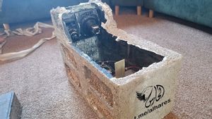
They put photos and videos showing cracked roads, damaged buildings and cars, and items on supermarket shelves fell.
So far, there have been no reports of casualties or official statements regarding the damage caused by this earthquake.
Earthquakes often occur in Papua New Guinea.
The country's territory is known to be on the Pacific Ocean's "fire ring" route, an area prone to seismic activity due to friction between tectonic plates.
In 2018, more than 100 people were killed, and thousands of houses damaged by the 7.5 magnitude M earthquake in remote mountainous areas of PNG.
The English, Chinese, Japanese, Arabic, and French versions are automatically generated by the AI. So there may still be inaccuracies in translating, please always see Indonesian as our main language. (system supported by DigitalSiber.id)
Tags les plus populaires
#Prabowo Subianto #Nouvel An #pdip #Hasto Kristiyanto #nataru #NatalPopulaire