

JAKARTA - Tropical cyclone Charlotte continues to move away from Indonesian territory. However, the indirect impact in the form of extreme weather still has the potential to occur in the areas of Java, Bali and West Nusa Tenggara (NTB).
"Medium-heavy rain that can be accompanied by strong winds in several provinces, namely Banten, West Java, Central Java, Yogyakarta, East Java, Bali and West Nusa Tenggara," said Deputy for Meteorology, Meteorology, Climatology and Geophysics Agency (BMKG). ), Guswanto in a written statement received in Jakarta, Antara, Monday, March 21.
In addition to moderate to heavy rainfall, the indirect impact in the next 24 hours in the form of strong winds also has the potential to occur in southern Lampung, Banten Sunda Strait, DKI Jakarta, and the southern waters of Java.
Sea waves with a moderate height or 1.25-2.5 meters also have the potential to occur in the Java Sea, the southern waters of Lombok Island to Sumba Island, the Bali - Lombok - Alas Strait in the southern part, the western part of the Sumba Strait and the southern Indian Ocean in NTT.
Meanwhile, wave heights of 2.5 to 4 meters have the potential to occur in the southern waters of the island of Java to the island of Bali, the Indian Ocean south of Java to NTB.
In addition, it is also necessary to watch out for the potential for swell waves to cause coastal flooding in the southern waters of Java and Bali-Lombok-Sumbawa Island.
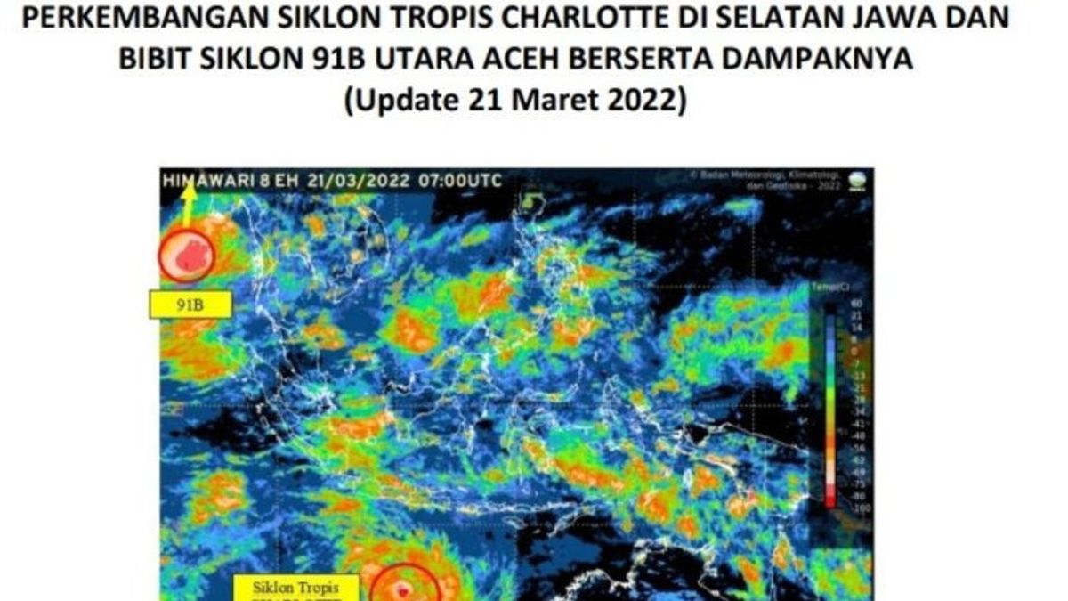
Tropical cyclone Charlotte is a tropical cyclone system formed from the seed system of cyclone 93S since Thursday, March 17 which began to form around East Nusa Tenggara.
Tropical Cyclone Charlotte began to form in the Indian Ocean south of East Java, precisely at 14.6LS and 112.3BT with maximum wind speeds around the system reaching 40 knots (75 km/hour) and minimum air pressure at its center of around 996 hPa.
Given that Tropical Cyclone Charlotte's growth location is already in Australia's area of responsibility, the naming system has been released by TCWC Australia.
In addition to tropical cyclone Charlotte, BMKG is also monitoring the presence of tropical cyclone 91B in the Andaman Sea north of Aceh, to be precise at 12.1 North Latitude and 94.9 East Longitude with maximum wind speeds of around 30 knots (54 km/hour) and minimum air pressure at the center of around 998.9 hPa with movement of the system to the north.
The indirect impact in the next 24 hours from the presence of tropical cyclone 91B on weather conditions in Indonesia is moderate-heavy rain which can be accompanied by strong winds in several areas in Aceh province.
Wave height of 1.25 - 2.5 meters or moderate has the potential to occur in the western waters of Aceh to Nias Islands, northern waters of Sabang Island. Meanwhile, the wave height of 2.5 - 4.0 meters (Rough Sea) has the potential to be in the northern part of the Malacca Strait, the West Indian Ocean from Aceh to Nias as well as the square waves causing coastal flooding in the western Indian Ocean region of Aceh to Nias Island.
The English, Chinese, Japanese, Arabic, and French versions are automatically generated by the AI. So there may still be inaccuracies in translating, please always see Indonesian as our main language. (system supported by DigitalSiber.id)
Tags les plus populaires
#Prabowo Subianto #NCP #Palestine #tangerang sea fence #efesiensi anggaran #iims 2025Populaire