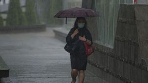


JAKARTA - The Meteorology, Climatology and Geophysics Agency (BMKG) warned that the potential for strong winds could still occur in several parts of Indonesia within the next two days. km per hour there is still potential for this to occur for the next two days," said BMKG Deputy for Meteorology Guswanto in a written statement from the BMKG in Jakarta, Monday, March 7. South and South Sulawesi. The strong winds were triggered by a cyclonic circulation pattern in the waters of the Timor Sea which forms a wind confluence pattern in the areas of Lampung, Banten, Jakarta, Bogor, Depok, Tangerang, Bekasi, southern Kalimantan, Sulawesi and Nusa Tenggara. .
Guswanto said that entering the period from March to April 2022, most areas in the country will enter a transitional period, namely from the rainy season to the dry season (transitional). Therefore, the public is advised to remain vigilant in case of extreme weather such as heavy rains of short duration accompanied by strong winds, lightning and lightning or tornadoes. damage to buildings, especially in vulnerable areas. As for stakeholders, it is hoped that they can continue to coordinate with all relevant parties who handle disasters. Previously, strong winds had occurred around the Banten and Jabodetabek areas. The occurrence of strong winds was also followed by rain with light to heavy intensity in a short duration, so that several public facilities were damaged. BMKG assessed that the incident was triggered by a cumulonimbus (Cb) type of convective cloud system that moved from the west of Banten to the east towards the Jabodetabek area with dimensions cloud system that extends from north to south -13.00 WIB, such as in South Tangerang 57 km per hour and Cengkareng 52 km per hour.
The English, Chinese, Japanese, Arabic, and French versions are automatically generated by the AI. So there may still be inaccuracies in translating, please always see Indonesian as our main language. (system supported by DigitalSiber.id)