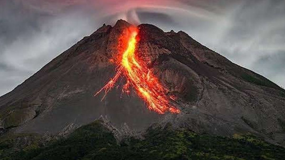


SLEMAN - Mount Merapi's activity was still high on Monday, February 23 morning. The Geological Disaster Technology Investigation and Development Center (BPPTKG) reported that lava flows occurred with a maximum run-out distance of 2 kilometers.
The active volcano, which is on the border of the Yogyakarta Special Region (DIY) and Central Java, has been recorded to have experienced five lava eruptions during the observation period from 00.00 WIB to 06.00 WIB.
Based on the official report of BPPTKG, the lava discharge leads to Kali Krasak with a maximum sliding distance of 2,000 meters.
BPPTKG Head Agus Budi Santoso emphasized that until now the status of Mount Merapi is still at level III or alert.
"Five times the lava discharge was observed towards Kali Krasak with a maximum drift distance of 2,000 meters," Agus said in an official statement, Monday, February 23.
In terms of earthquakes, Merapi activity is still intense. There were 33 aftershocks with an amplitude of 1-39 mm and a duration of 65.79-170.69 seconds.
In addition, there were 31 hybrid or multiple phase earthquakes with an amplitude of 1-26 mm and a duration of 12.72-40.45 seconds. BPPTKG also recorded three distant tectonic earthquakes during the observation period.
This data shows that the magma supply and internal dynamics of Mount Merapi are still active so that the potential for lava eruptions and hot clouds still need to be considered.
From the meteorological point of view, the weather around Mount Merapi was observed to be cloudy to overcast. The wind blew weakly to the west with an air temperature ranging from 18.3-20 degrees Celsius.
Air humidity was recorded between 88%-98.9% with air pressure of 870.5-913 mmHg. Visually, the peak of the mountain was covered by fog 0-III and no smoke was observed from the crater.
BPPTKG said the current potential danger was the ejection of lava and ejection hot clouds, especially in the south-southwest sector which includes the Boyong River up to a maximum of 5 kilometers, as well as the Bedog, Krasak, and Bebeng Rivers up to a maximum of 7 kilometers.
Meanwhile, in the southeast sector, potential hazards include the Woro River up to 3 kilometers and the Gendol River up to 5 kilometers.
The public is urged not to carry out activities in the potential danger area of Mount Merapi. Residents are also asked to be aware of the threat of lava and falling hot clouds, especially when it rains around the slopes of Merapi.
The alert status (level III) indicates a significant increase in volcanic activity and has the potential to cause an eruption at any time. Therefore, the public and stakeholders are asked to continue to monitor official information from BPPTKG regarding the development of Mount Merapi's activity today.
The English, Chinese, Japanese, Arabic, and French versions are automatically generated by the AI. So there may still be inaccuracies in translating, please always see Indonesian as our main language. (system supported by DigitalSiber.id)
Most Popular Tags
#Prabowo Subianto #donald trump #2026 World Cup #Febrie Adriansyah #8791Popular


