


JAKARTA - The activity of Mount Tangkuban Parahu in the northern region of Bandung City, had increased in the last week of June 2025.
Head of the Geological Agency of the Ministry of Energy and Mineral Resources, Muhamad Wafid, explained that based on observations until June 27, 2025 at 24.00 WIB, the earthquake activity of Tangkuban Parahu is still dominated by tremors that are associated with mud boast activities in the Ratu Crater.
Footage of seismicity on the 24th and 25th of June 2025 has increased low-Frequency (LF) earthquakes in stages, namely 90th and 103th of each incident per day. Monitoring data on June 26, 2025, the number of LF earthquakes recorded as many as 116 events, 1 Internal Volcanic Earthquake (VA) and continuous tremors with an amplitude of 0.5 - 1 mm.
"Meanwhile, on June 27, there were 97 LF earthquakes with an amplitude of 2-27 mm, and an earthquake of 8-26 seconds. 2 gusts with an amplitude of 8-10 mm, and a long earthquake of 31-33 seconds. 2 Shallow Volcanic earthquakes with an amplitude of 6 mm, and a long earthquake of 9-10 seconds. As well as 1 distant Tectonic earthquake with an amplitude of 10 mm, S-P 10 seconds and a long earthquake of 31 seconds," Wafid said quoting Antara.
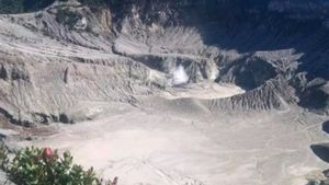
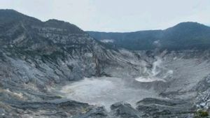
For visual observations, thin to moderate white smoke gusts were observed with heights ranging from 5 to 180 meters from the bottom of the Queen Crater and 5 to 15 meters from the bottom of the Ecoma Crater with weak to moderate pressure.
"The manifestation of mud talk in the Ratu Crater which was formed on June 5, 2025, is still being observed, the level of intensity and area of mud talk is still the same compared to activities on June 26, 2025," he said.
Observations of surface deformation using EDM and GNSS tools, he continued, still show an inflation pattern, which indicates an accumulation of pressure at a shallow depth below the volcano's body.
"This is still a concern because the potential for phreatic eruptions can still occur suddenly, without being preceded by clear volcanic symptoms," he said.
Meanwhile, gas measurement data from the Multi-GAS station is permanent, he said, has not shown any striking changes to the gas ratio (CO2/SO2, CO2/H2S, H2O/CO2, H2S/SO2) as well as the proportion between SO2 and H2S gas.
By considering all these data, the Geological Agency stated that the level of activity of Mount Tangkuban Parahu was still at Level I (Normal).
However, the people around Mount Tangkuban Parahu and visitors are still advised not to approach the bottom area of the crater, not to linger in the active crater area, and to move away immediately if the intensity of the gusts is observed or the smell of strong gas.
The Regional Government and BPBD are also asked to continue to coordinate with the Tangkuban Parahu Volcano Observation Post in Cikole Village and the Center for Volcanology and Geological Disaster Mitigation (PVMBG) in Bandung.
The community itself is expected to remain calm, not easily influenced by issues that cannot be accounted for, and to follow the development of official information.
SEE ALSO:
-
 | BERITA
Dedi Mulyadi Minta Pakar Kaji Dampak Proyek Eiger di Tangkuban Perahu dan Puncak
08 April 2025, 17:05
"The evaluation of the activity level of Mount Tangkuban Parahu will be carried out regularly or at any time if there is a significant change. The community is expected to remain calm, alert, and follow directions from the authorities for the sake of mutual safety," he said.
Mount Tangkuban Parahu is known to be an active volcano located in the border areas of West Bandung Regency and Subang Regency, West Java Province, which is also one of the destinations by tourists from within and outside the country.
This volcano has 9 craters with two main craters in the summit area, namely the Queen Crater and Upas Crater. The eruption of Mount Tangkuban Parahu is generally a phreatic eruption from the Queen Crater.
The English, Chinese, Japanese, Arabic, and French versions are automatically generated by the AI. So there may still be inaccuracies in translating, please always see Indonesian as our main language. (system supported by DigitalSiber.id)
Most Popular Tags
#Prabowo Subianto #donald trump #Febrie Adriansyah #8791 #giias 2026Popular


