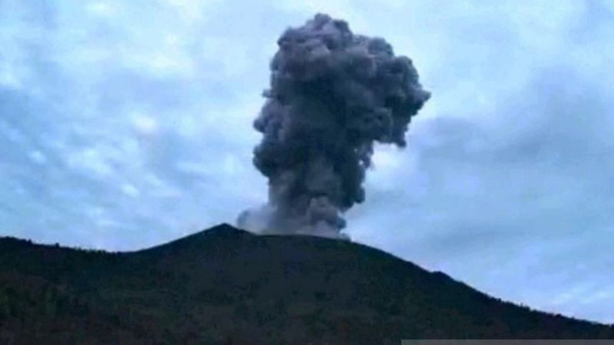


JAKARTA - The Geological Agency of the Ministry of Energy and Mineral Resources (ESDM) has lowered the status of Mount Ibu, West Halmahera, North Maluku, to Alert (Level III) with a danger zone that residents should avoid at a radius of 4 kilometers from the direction of the active crater opening.
Head of the Geological Agency, Muhammad Wafid, said that the level of activity of Mount Ibu was lowered from Alert (Level IV) on Tuesday, January 28, which was carried out based on visual and instrumental observations showing a decline in volcanic activity from the strato mountain.
Officers at the Mount Ibu observation post in Gam Ici Village, West Halmahera found that in mid-127 January the number of seismicities recorded and the height of the eruption column began to decline.
In addition, the eruption accompanied by incandescent lava has also begun to decrease compared to the previous two weeks (1-14 January) and including the screening distance is also decreasing, which is within a radius of 500 meters from the crater lip.
However, according to Wafid, residents in West Halmahera who are outside a 4 kilometer radius and are outside the sector 5 kilometers from the opening of the active crater of Mount Ibu still have to increase their vigilance while still complying with the directives from the local government.
According to him, in the same period, white and gray main crater smoke was also observed with thin to moderate intensity, about 100-600 meters from the summit. The deformation data, namely the electronic distance measurement (EDM) also shows a deflation trend.
The Geological Agency confirmed that there was a burst of sound and a roar at several eruptions to the mother's observation post, accompanied by incandescent lava that reached a radius of about 1.5 kilometers from the crater's lips.
"The seismic activity during the January 1 27 period was dominated by shallow volcanic earthquakes, eruptions, gusts, and distant tectonic earthquakes that still occur every day," Wafid said in a statement in Jakarta, Thursday, January 30.
During this period, his party recorded 1,747 eruption earthquakes, 87 avalanches earthquakes, 2,976 gusts, 427 harmonic earthquakes, 25 tornillo earthquakes, 11,746 shallow volcanic earthquakes, 665 deep volcanic earthquakes, 88 local tectonic earthquakes, 1 earthquake was felt (Scale IV MMI), and 522 distant tectonic earthquakes.
The Geological Agency reminded the community around Mount Ibu to also be aware of the potential for lava in rivers that originate from the peak when heavy rains occur, because the accumulation of volcanic material at the top of Mount Ibu's potential for lava avalanches is also getting bigger.
SEE ALSO:
-
 | BERITA
Wanita 48 Tahun Hilang di Kebun Cengkeh, Ketakutan saat Ditemukan Basarnas Natuna
28 Januari 2025, 11:41 -
 | BERITA
Menteri P2MI Ungkap Malaysia Masih Tutup Akses Temui WNI Korban Penembakan
27 Januari 2025, 12:32


The results of a recent survey by geological officers with the National Disaster Management Agency (BNPB) last year, it was found that at least 300-500 thousand cubic meters of volcanic material deposited around the active crater of Mount Ibu and at any time carried down with heavy rains through the four existing rivers.
The English, Chinese, Japanese, Arabic, and French versions are automatically generated by the AI. So there may still be inaccuracies in translating, please always see Indonesian as our main language. (system supported by DigitalSiber.id)


