JAKARTA - The rainy season has started to greet you. The DKI Regional Disaster Management Agency (BPBD) has mapped 25 flood-prone spots in Jakarta which are expected to start in the second week of December. The mapping of this location is based on an analysis of the ground level and the duration of flooding for the last three years.
The 25 points are spread across the four administrative cities of Jakarta. In West Jakarta, flood-prone areas are in the Kelurahan of Rawa Buaya, Tegal Alur, Kedoya Selatan, Kedoya Utara, and Kembangan Utara. Meanwhile in South Jakarta, the areas prone to flooding are in the Kelurahan of North Cipete, Petogogan, Cipulir, Pondok Pinang, Rawajati, Ulujami, Pondok Labu, Bangka, Pejaten Timur, and Jatipadang.
Meanwhile, flood-prone areas in East Jakarta include Bidara Cina, Kampung Melayu, Cawang, Cililitan, Cipinang Melayu, Makassar and Rambutan. Then, North Jakarta, which is prone to flooding, is located in Pademangan Barat, Pluit and Penjaringan Kelurahan.
In these 25 urban villages, BPBD has conducted socialization and simulation assistance to the community so that they are ready to face the possibility of future floods.
"We also ensure that the early warning system is functioning properly, so that it will provide accurate information which can later be disseminated to the public," said Head of BPBD DKI Subejo, yesterday.
"For example, Katulampa is on standby 3 or the altitude rises. It is estimated that it will be 9 hours to Manggarai. We have warned via SMS," he added.
In addition, BPBD has prepared a route to the nearest refugee camp, and distributed foodstuffs and basic necessities for the refugees when the floods came.

Another anticipatory step is that the DKI Water Resources Agency has been dredging reservoirs and rivers since July. The goal is to increase the discharge capacity of reservoirs, channels or rivers in DKI. So that rainwater and times can be accommodated properly.
Then, as many as 4,000 pumps, both stationary and mobile, had also been prepared at several points when the tires were stagnant. There are also 7,800 task forces assigned to each pump.
"There are officers guarding the pumps, then there are officers who clean the channels and reservoirs. So, during the rainy season, when the atmosphere is getting dark we order the officers to standby in several locations which have been considered prone to inundation," said Head of SDA Juaini Yusuf. .
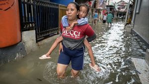
The VOI team visited the RW 007 area of Bidara Cina Village, Jatinegara, East Jakarta. This RW is one of the areas that is regularly flooded every rainy season. Floods often come to this village because of its proximity to the banks of the Ciliwung river.

Apart from Bidara Cina, the residential areas around the Ciliwung River are Kampung Melayu, Kampung Pulo, and Bukit Duri. All of these areas are also frequently flooded.
When entering the RW 007 area of Bidara Cina Village, the land immediately changes to be lower than the RW in front of it, which is closer to Jalan Raya. This RW has branching alleys. At the end of the alley, the river flows at the back of the residents' houses.

One of the residents of RW 007, named Fha Toni (27), said that this house is regularly flooded during the rainy season. Even though he is a regular, Toni said, residents of RW 007 rarely socialize flood mitigation from the whole area. However, he did not question it because he already knew what to do if the flood hit.
"The floods here have been going on for years, so we are used to it. The people here understand how to anticipate flooding," said Toni, Friday, November 15.
In his opinion, the Head of Bidara Cina Village, Dadang Yudi, admitted that flooding is a common thing for its residents. Therefore, there is no need for regular socialization about flooding.
During floods in May, the flood depth in Bidara Cina can reach 2.5 meters. The most affected areas are RW 007 and RW 11 because geographically they are very close to the riverbanks. Based on that experience, residents already understand how to anticipate flooding and prepare to evacuate.
Dadang always gets information from BPBD regarding the status of the water level from the Katulampa Dam which flows into the Ciliwung River in the rainy season. This information is then passed on to residents to prepare for flooding.
When the water level threatens, Dadang will coordinate with all person in charge (PIC) in each RW via the WhatsApp group. After that, the PICs will forward this notification to the residents. Residents are asked to save their belongings and prepare to take refuge in the courtyard of Bidara Cina Village.

"For example, within a few hours the altitude in Katulampa is already worrying. We are forwarding information to residents to get ready to evacuate. So, there is still time to clean up," said Dadang.
He added that Bidara Cina Village also has a pump which functions to reduce water discharge from residential areas. There are two pumps, one is working fine, the other has a problem. Meanwhile, there is another pump which is portable which can be moved.
Apart from the pump, this village has 8 infiltration wells. But after all, what Dadang is waiting for is the process of normalizing the river. He is sure that with this process, flooding in his sub-district can be handled properly.
"If the normalization project goes ahead, God willing, it can really reduce it, but normalization is still in Kampung Melayu, not here yet," he concluded.
The English, Chinese, Japanese, Arabic, and French versions are automatically generated by the AI. So there may still be inaccuracies in translating, please always see Indonesian as our main language. (system supported by DigitalSiber.id)
