

JAKARTA - The Meteorology, Climatology and Geophysics Agency (BMKG) stated that Tropical Cyclone Charlotte, a tropical cyclone system formed from the cyclone 93S seed system since March 17, 2022, is certain to stay away from Indonesian territory and rain will hit several provinces.
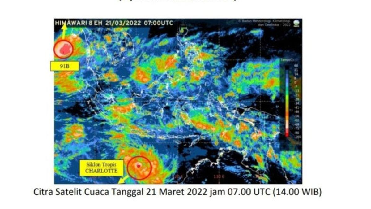
BMKG Deputy for Meteorology Guswanto said the tropical cyclone was starting to form around NTT or around the Indian Ocean south of East Java, to be precise at 14.6LS and 112.3BT; with maximum wind speeds around the system reaching 40 knots (75 km/h) and minimum air pressure at the center of about 996 hPa.
"The movement of the Charlote system is towards the southwest away from Indonesian territory. Given that the location of Tropical Cyclone Charlotte's growth is already in Australian territory, the naming system has been released by TCWC Australia," said Guswanto as quoted by Antara, Monday, March 21.
He said the indirect impact in the next 24 hours from the presence of tropical cyclone Charlotte on weather conditions in Indonesia is moderate to heavy rain which can be accompanied by strong winds in several areas in the provinces of Banten, West Java, Central Java, Yogyakarta, East Java. , Bali, West Nusa Tenggara.
Then it has the potential to cause strong winds in the southern part of Lampung, the Sunda Strait, Banten, DKI Jakarta, the southern waters of Java.
Then it triggers a wave height of 1.25 - 2.5 meters (moderate) in the Java Sea, the southern waters of the Lombok Island to the Sumba Island, the southern part of the Bali - Lombok - Alas Strait, the western part of the Sumba Strait, the southern Indian Ocean of NTT.
Then the wave height is 2.5 - 4.0 meters (rough sea) in the waters south of Java to Bali, the Indian Ocean south of Java to NTB. The swell wave causes coastal flooding in the southern waters of Java and Bali-Lombok-Sumbawa.
Not only Tropical Cyclone Charlotte, seedlings of tropical cyclone 91B are also still being observed in the Andaman Sea north of Aceh, precisely at 12.1 North Latitude and 94.9 East Longitude with maximum wind speeds of around 30 knots (54 km/hour) and minimum air pressure at the center of around 998.9 hPa.
"The movement of the system is to the north, and has indirect impacts within 24 hours, such as moderate-heavy rain which can be accompanied by strong winds in several areas in Aceh province," said Guswanto.
In addition, it causes a potential wave height of 1.25 - 2.5 meters (moderate) in the western waters of Aceh to Kep. Nias, northern waters of Sabang Island.
Then the wave height of 2.5 - 4.0 meters (Rough Sea) in the northern part of the Malacca Strait, the western Indian Ocean from Aceh to Nias, and the swell wave causing coastal flooding in the western Indian Ocean region from Aceh to Nias.
BMKG through the Jakarta TCWC (Tropical Cyclone Warning Center) continues to monitor the development of the potential for Tropical Cyclones and other atmospheric dynamics activities as well as the potential impacts of extreme weather. Associated with the potential for extreme weather.
Guswanto appealed to the public to avoid shipping activities in the affected waters, and to avoid areas prone to disasters such as river valleys, slopes prone to landslides, trees that fall easily, beaches, and others.
Then be aware of potential impacts such as floods/flash/coastal floods, landslides and flash floods, especially in vulnerable areas.
The English, Chinese, Japanese, Arabic, and French versions are automatically generated by the AI. So there may still be inaccuracies in translating, please always see Indonesian as our main language. (system supported by DigitalSiber.id)


