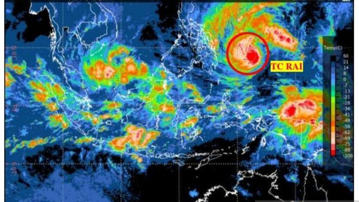


JAKARTA - The Meteorology, Climatology and Geophysics Agency (BMKG) stated that moderate to heavy rain accompanied by strong winds could potentially occur in Aceh and North Sumatra due to Tropical Cyclone RAI and the formation of Cyclone 94B seeds around the Andaman Sea.
"Tropical Cyclone RAI and the seeds of Cyclone 94B can have an indirect impact on the potential for rain with moderate to heavy intensity in Aceh and North Sumatra. The potential for strong winds in the northern part of Aceh", said Deputy for Meteorology, Guswanto, in a written statement quoted by Antara, Monday, December 20.
In addition, Cyclone RAI and the seeds of Cyclone 94B caused sea wave heights of 1.25-2.5 meters in the northern part of the Malacca Strait, the waters of Meulaboh to the Sinabang Islands, the waters of the Nias Islands to Sibolga, the waters of the Anambas Islands, the southern waters of the Natuna Islands, and Natuna Sea.
Wave heights of 2.5-4 meters have the potential to occur in the northern waters of Sabang, the western waters of Aceh, the western waters of Simeulue Island to the Nias Islands, the western Indian Ocean from Aceh to Nias, the northern Natuna Sea, the northern waters of the Natuna Islands, and the waters of the Subi Serasan Islands.
Guswanto explained that the seedlings of Cyclone 94B were located at 5.2 North Latitude - 94.5 East Longitude with the lowest pressure at its center reaching 1,007 MB and the maximum wind speed around the system was around 25 knots (46 km/hour).
BMKG will continue to monitor the development of this cyclone seed. In the next 24 hours, the probability of Cyclone 94B's seeds turning into a tropical cyclone system is still relatively low.
"Seedlings of Cyclone 94B grew in the area of responsibility of the RSMC (Regional Specialized Meteorological Center) Tokyo, so the authorization for the analysis and naming of the cyclone system will be carried out by the Regional Specialized Meteorological Center (RSMC) Tokyo", he said.
SEE ALSO:
-
 | BERITA
'Pemimpin Indonesia Masa Depan', Sebutan PWNU DKI untuk Gubernur Anies Baswedan
20 Desember 2021, 18:27


Tropical Cyclone RAI is currently at a position of 17.2 LU-110.8 east longitude (about 1,640 km north-northeast of Tarempa) with maximum wind speeds around its center reaching 70 knots (130 km/hour) and air pressure at its center of around 970 hPa.
For the next 24 hours period, Tropical Cyclone RAI is moving towards the northeast, further away from Indonesian territory, and tends to weaken in intensity.
Due to the presence of Cyclone RAI and the seeds of Cyclone 94B, the BMKG appealed to the public to avoid shipping activities in the affected waters, to avoid areas prone to disasters, such as river valleys, slopes prone to landslides, trees that fall easily, and beaches.
He also asked residents to be aware of potential floods, flash floods, coastal floods, landslides, especially in vulnerable areas.
BMKG also encourages related officials to intensify coordination in the context of anticipating hydrometeorological disasters.
"Always monitor the development of weather forecast information and extreme weather early warnings from the BMKG through the BMKG information channel", he said.
The English, Chinese, Japanese, Arabic, and French versions are automatically generated by the AI. So there may still be inaccuracies in translating, please always see Indonesian as our main language. (system supported by DigitalSiber.id)


