

JAKARTA - At night, February 13, 2014, the late Sutopo Purwo Nugroho announced that Mount Kelud in East Java had erupted. Sutopo, who was then Head of the Data Center, Information and Public Relations of the National Disaster Management Agency (BNPB), announced that the eruption occurred at around 22:50 WIB.
Mount Kelud is on the border between Kediri, Blitar and Malang. The eruption was incredible. Volcanic ash covered the sky in several cities across the four provinces. Pitch black. Activity was paralyzed. The sound of the eruption of Mount Kelud was also heard as far away as Yogyakarta.
The Kompas daily, published on February 14, 2014, reported that several hours after Sutopo announced the eruption situation, precisely at 23.30 WIB, the hot clouds had reached an altitude of 17 kilometers. As a result of that incident, four people died. Hundreds of thousands of residents were evacuated.
The records of the Meteorology, Climatology and Geophysics Agency (BMKG) explained that ash and sand in the 1,500 meter layer were carried to the northeast. Meanwhile, ash and sand in layers of 5,000 and 9,000 meters flew to the west.
PreparationThe activity of Mount Kelud showed a significant increase in the days before the eruption. The daily Kompas, 12 February 2014 reported that one day before the eruption, 43 deep volcanic earthquakes were recorded and 149 shallow volcanic earthquakes were recorded. The entire earthquake was monitored from 00.00 WIB to 06.00 WIB.
The authorities also noted that the crater water temperature reached 56.9 degrees Celsius. Based on these various conditions, the authorities are preparing for an eruption.

The local disaster management unit, together with sub-district officials, determine the points of gathering locations for evacuation in each RT. Not only refuge. Facilities for supporting refugees have also begun to be provided.
The water tanker owned by the Indonesian Red Cross (PMI) was alerted at a number of locations around the slopes of Mount Kelud.
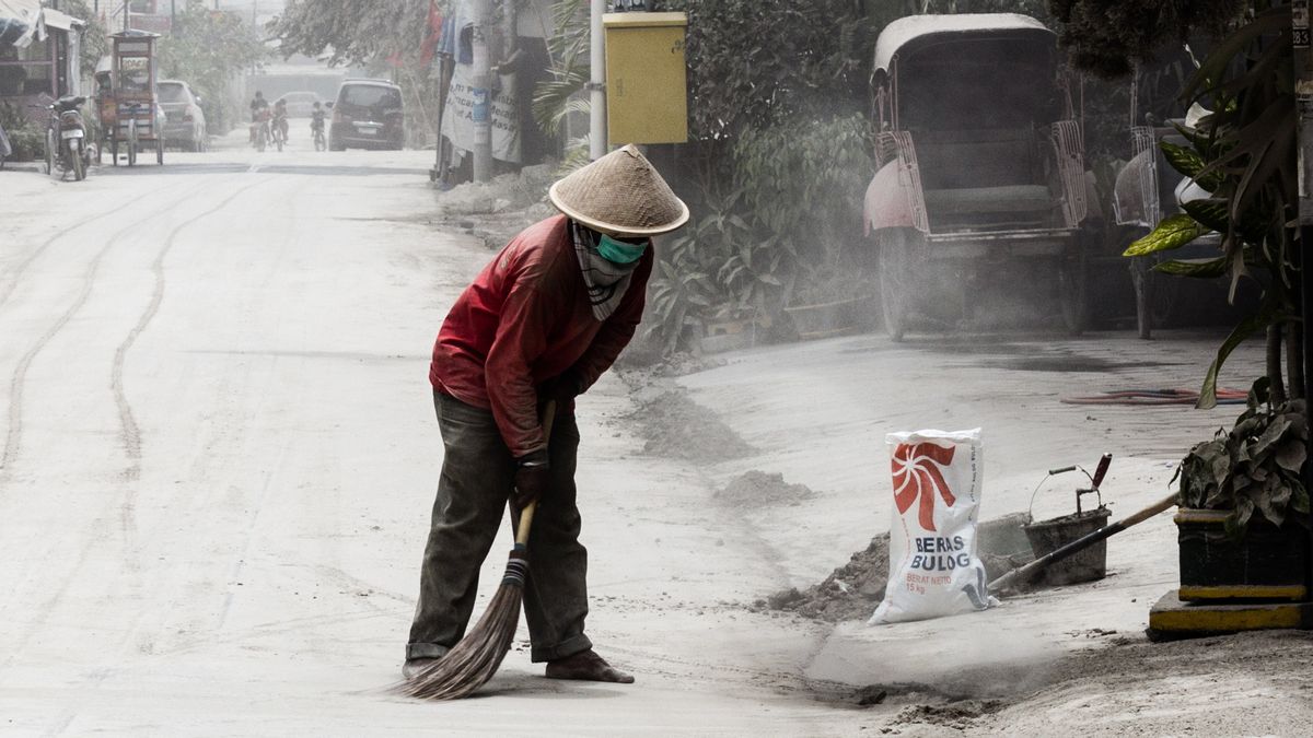
Post-eruptionAfter the eruption, the activities of residents in various cities were disrupted. In Solo, for example. Visibility is rarely observed only 50-100 meters. The worst can reach only 10 meters.
Ash rain has also been observed in other areas, from Sukoharjo, Klaten, Boyolali, Karanganyar, to Sragen. Shops in the Special Region of Yogyakarta were closed, especially in Sleman, Kulon Progo and Yogyakarta City.
Likewise with the street vendors. In Malioboro and Jalan Solo, none of them trade.

According to a resident of Jalan Bantul, Aris (45), in a Kompas daily report, February 15, 2014, "This (Mount Kelud eruption) is much worse than the previous eruption of Merapi."
In Banyumas, the rain is cloudy because it falls with the ash. Panic has started to hit residents of Kebumen, Central Java, which is 400 kilometers from Mount Kelud.
Volcanic ash fell rapidly in the morning 06.00 WIB. Dozens of motorbikes have skidded due to the slippery road covered in volcanic ash.
Cover part of Java IslandThe eruption of Mount Kelud in 2014 was the largest in the modern era. Apart from East Java and Central Java, the eruption of Mount Kelud caused ash rain that flew to West Java.
In Bandung, the Chairman of the Mount Kelud Activity Monitoring Team from PVMBG Bandung Umar Rosyadi explained the enormity of the eruption of Mount Kelud. The height of the ejection material is up to a radius of 17 kilometers into space. This is evidence of the magnitude of the Mount Kelud magma explosion.
"This is the biggest eruption in the history of Mount Kelud," said Umar, quoted by Liputan6.com, Friday, February 12.

The impact of Mount Kelud's volcanic ash in West Java reached Ciamis Regency, Bandung, and several other areas. On the afternoon of February 14th, ash rain from the eruption of Mount Kelud paralyzed the island of Java.
Seven airports in Yogyakarta, Surakarta, Surabaya, Malang, Semarang, Cilacap and Bandung have to close for more than a week. Hundreds of thousands of people from five districts, namely Kediri, Malang, Blitar, Batu and Tulungagung had to evacuate.
BNPB officially recorded the number of refugees on the first day after the eruption reached 76,388 people. Most of them are dominated by children, the elderly and mothers. In a mathematical calculation, the population in a radius of 10 kilometers in the area affected by the eruption is approximately 150 thousand people.

The impact of the damage caused by the eruption of Mount Kelud was extraordinary. East Java Provincial Government data recorded 12,304 houses damaged. Most of the damage occurred on the galvalume roof of the house, which collapsed due to the inability to hold the sand. The tiles were also broken because of the throwing stones.
Material losses due to airport closures are estimated at billions of rupiah, including around Rp. 2 billion at Juanda International Airport in Surabaya. The most severe damage was suffered by the manufacturing sector and the agricultural industry.
Apple orchard in Batu, East Java, posted a loss of up to IDR 17.8 billion. Meanwhile, the dairy industry recorded even more losses due to milk contaminated with dust and dairy cows that do not emit milk.
TODAY'S HISTORY OthersThe English, Chinese, Japanese, Arabic, and French versions are automatically generated by the AI. So there may still be inaccuracies in translating, please always see Indonesian as our main language. (system supported by DigitalSiber.id)

Related News