

JAKARTA - After crashing ntt, now Tropical Cyclone Seroja is predicted to increase in the next 24 hours. Areas requested to be vigilant include Central Java, East Java, Bali, and West Nusa Tenggara (NTB). This cyclone is recorded to be the most dangerous than any other cyclone that has ever crossed Indonesia.
The news was delivered by the Bureau of Meteorology, Climatology and Geophysics (BMKG) through a written statement. According to the data, despite the increase, the direction of the cyclone moves away from The Indonesian territory towards the southwest.
BMKG stated that the area requested to be alert has the potential to experience moderate to heavy intensity rain accompanied by lightning or lightning and strong winds. In addition to heavy rain, waves as high as 2.5-4.0 meters are likely to occur in the southern waters of Java, the Indian Ocean south of Bali to East Nusa Tenggara. Waves as high as 4-6 meters are also likely to occur in the Indian Ocean south of Java.
Crashing two countriesPreviously Tropical Cyclone 99S or Tropical Cyclone Seroja has ravaged two countries at once. The eastern part of Indonesia is East Nusa Tenggara and east Timor.
In NTT, according to data collected until Wednesday, April 7, night, the total fatalities in several districts and cities affected amounted to 138 people. There are still 61 people declared missing.
Meanwhile, material losses in the housing sector amounted to 1,114 units. The details are a house heavily damaged 688 units, moderately damaged 272 and lightly damaged 154.
Meanwhile, in East Timor, 34 people were declared dead and a number of people were missing due to flash floods triggered by Tropical Cyclone Seroja. According to data obtained from the East TimorEse Civil Guard cited by CNNIndonesia, the death toll was recorded in a number of areas.
From the data there were 13 deaths in Dili, 12 deaths in Manatuto, seven in Ainaro, one in Baucau, and one in Aileu, as quoted by Xinhua news agency on Thursday, April 8. According to reports, flash floods caused by Tropical Cyclone Seroja affected 10 thousand people and damaged a number of homes, public facilities, roads and bridges.

BNPB Chief Doni Monardo crosses a broken bridge in Alor NTT Regency (DOK BNPB)
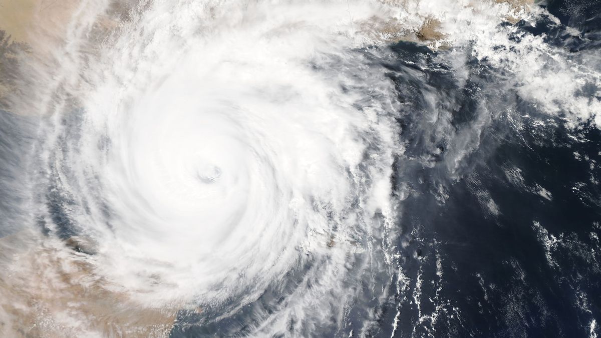
A tropical cyclone is a large force storm formed from a low air pressure system in the waters around the tropics. Tropical cyclones form in the ocean and will become extinct or weaken when entering cold water areas or entering land.
As quoted bmkg tropical cyclone page is certainly different from the nipple. Cyclones form in vast oceans that have sea surface temperatures of more than 26.50 C and move away from equatorial latitudes, while pickaxe nipples occur from cumulunimbus (Cb) clouds and move in the direction of motion of the Cb cloud.
Meanwhile, tropical cyclones on average survive about 3 to 18 days, while the maximum duration of occurrence is only 5 minutes. The damage caused by tropical cyclones is certainly more severe than the nipples.
Tropical cyclones can have a huge impact on the areas they pass through, such as strong winds, heavy rains, floods, high waves and storm surges in the sea. From here a little bit we can know why Tropical Cyclone Seroja is considered incompetent as called head of BMKG Dwikorita Karnawati.
As already explained, tropical cyclones generally form in the sea and will weaken when entering cold water areas or entering land. Meanwhile, according to Dwikorita, Cyclone Seroja that occurred in NTT, the largest vortex occurred on the mainland. Even at the beginning of its formation, the speed of this cyclone vortex reached 85 km per hour.
"This one, it's just starting to develop, that's what makes it awesome, imagine when it formed, the speed of the vortex is 85 km per hour. When it was formed it had entered Kupang, whose vortex was high on land," explained Dwikorita.
According to Dwikorita Cyclone Seroja is the first to enter mainland Indonesia. "Seems to be the strongest of the before."
Other cyclonesIn addition to Tropical Cyclone Seroja, several major cyclones that have passed through Indonesia are Cyclone Sempaka and Dahlia. Tropical cyclone Cempaka formed on November 27, 2017 at about 100 KM south-southeast of Cilacap. Meanwhile, Cyclone Topis Dahlia formed on November 29, 2017 south of Bengkulu.
The life span of Tropical Cyclone Dahlia is longer than tropical cyclone Cempaka which is 3 days old. Cyclone Dahlia occurred for 5 days.
Areas affected by Cyclone Dahlia include the southern part of Sumatra Island, Banten, DKI Jakarta, West Java, and Central Java. Tropical cyclones Cempaka and Dahlia that occur sequentially result in floods, landslides, and twisters in some areas such as Pacitan, Wonosobo, Yogyakarta, and Purworejo.
Compared to tropical cyclone Cempaka, the impact caused by tropical cyclone Dahlia is smaller, this is influenced by the position of tropical cyclone Cempaka which is closer to land. In addition, there are also other cyclones that have occurred according to BMKG, namely Tropical Cyclone Durga (2008), Tropical Cyclone Orchid (2010), and Tropical Cyclone Bakung (2014).
Wednesday, 29 Nov 2017 Tropical Cyclone DAHLIA, positioned at 19:00 WIB, is in the waters of the Southwest Indian Ocean of Bengkulu (540 km Southwest of Bengkulu) with a maximum wind speed of up to 65 km / h, moving eastwards at a speed of 8 km / h. #tcdahlia pic.twitter.com/P9gUvGVxlA
— BMKG (@infoBMKG) November 29, 2017
The question is, why is the name of this cyclone mostly taken from the name of the flower? The goal is so that the emerging tropical cyclone does not cause a sinister impression.
Tropical Cyclone Seroja is recorded to be the strongest of any other cyclone. Cyclone Seroja's maximum wind speed is around 85 km per hour. While the maximum speed of Tropical Cyclone Cempaka reaches 64 km per hour. While the speed of Cyclone Topis Dahlia reaches 65 km per hour.
Other BERNAS
The English, Chinese, Japanese, Arabic, and French versions are automatically generated by the AI. So there may still be inaccuracies in translating, please always see Indonesian as our main language. (system supported by DigitalSiber.id)

Related News