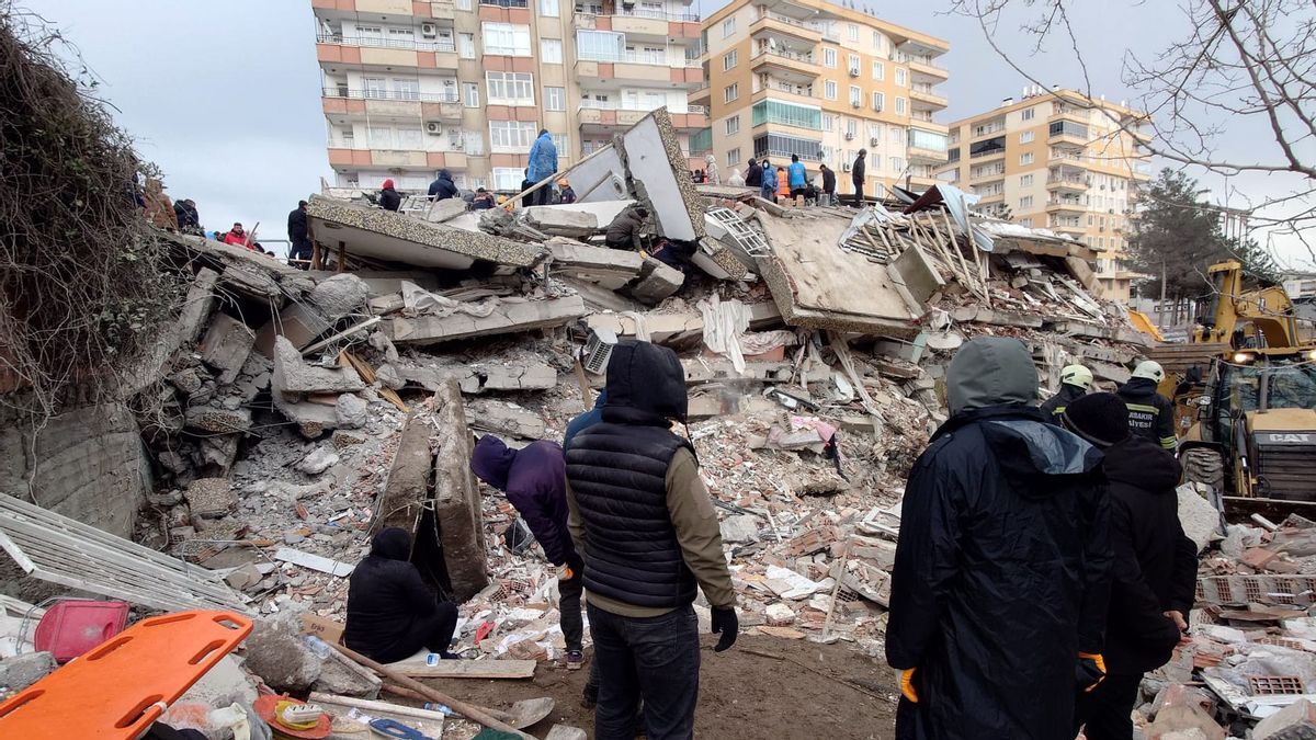


JAKARTA No less than 8000 people were killed in the Turkish earthquake disaster in the southern part of the country, which borders North Syria. The devastating disaster occurred on Monday morning, February 6, 2023, at 04.17 local time.
The Turkish earthquake became the deadliest natural disaster in early 2023. According to the United States Geological Survey (USGS) records, the epicenter of the earthquake was in the Nurdagi area in Gaziantep Province with a depth of 24.1 km. The strength of the first earthquake was recorded at a magnitude of 7.8.
The aftershocks that occurred were exacerbated by aftershocks that occurred up to 9 hours after the first shaking. The first aftershock appeared 11 minutes after the initial earthquake, which hit with a magnitude of 6.7. However, the most fatal aftershock occurred 9 hours later, which had a magnitude of 7.5.
Of the order of 100 aftershocks, the last earthquake was the strongest. And, the last impact that occurred 95 km from the initial earthquake really destroyed Gaziantep Province and its surroundings. Nearly 6000 buildings in South Turkey were destroyed, with fatalities reaching 8000 people.
The earthquake on Monday morning, February 6, was the strongest in Turkey since 1939. At that time, the impact of an earthquake with a magnitude of 7.8 and claimed 30 thousand lives.
Earthquakes can occur in any part of the earth. Starting from the highest mountain peak, to the deepest part of the sea. Also occurs in the coldest region in the South Pole, to the hottest part of the desert.
It should be noted, the USGS stated that an earthquake did not occur randomly. Even so, this natural event is unpredictable.
We and other scientists can never predict when a big earthquake will happen. We don't know how, and never hope to find a way either now or in the future. USGS scientists can only calculate the possibility that large earthquakes will occur in certain areas within a period of time. It is shown in our hazard mapping," the USGS wrote on the agency's website.
The strength of the earthquake was measured using a seismograph. This tool monitors seismic waves that propagate through the post-earthquake. For decades, the strength of the earthquake was measured using the Richter Scale Unit (SR), which was first used by US seismologist Charles Francis Richter in 1935.
But in today's times, the size of the earthquake's strength refers to the Modified Mercalli Intensity Scale (MMI). The USGS states that the measurement of the strength of the earthquake through this system with a magnitude unit is more accurate than that of the SR.
On a magnitude scale, the strength of the earthquake ranges from 3.0 (light earthquake) to >8.0 (super large earthquake). Each increase in one integer on a scale, describes an increase in energy power of 32 times!
The intense earthquake between Turkey and Syria on Monday morning, the vibrational effects can be felt until Israel and Lebanon are located hundreds of kilometers south. Turkey itself is indeed a country that is very earthquake-prone because it is located above the meeting of three tectonic plates, namely the Anatolyse Plate, the Eurasian Plate, and the Arabic Plate.
In the last 25 years in Turkey, there have been at least seven earthquakes with a magnitude of at least 7. However, those caught in Gaziantep with a magnitude of 7.8 were the strongest.
The earthquake has also been the strongest in the last two years, since the incident in the SouthEPTis Islands in the southern Atlantic Ocean. The earthquake that occurred in 2021 in the remote islands that became British territory had a magnitude of 8.1. Just because the area was almost uninhabited, the damage caused was almost nil.
The Gaziantep area is a seismogenic area. It is just above a very large fault zone. But this earthquake is the largest compared to the previous one. The earthquake can take a lot of victims and a devastating amount of damage due to a shallow epicenter," said Karl Lang, a researcher at Georgia Tech University School of Earth and Atmospheric Science in the United States, as quoted by CNN.
In contrast to Indonesia, which is located in the Ring of Fire area - a volcanic zone that stretches from the South Pacific, Southeast Asia, to South America - Turkey is located on top of a continental plate. The earthquake here is always due to subduction, one of which glides under another plate.
But in the case of the Turkish earthquake, it happened a little unique. Collision of continental plates does not result in vertical but horizontal effects, or known as strike slips.
That's why the buildings didn't sway, but collapsed immediately. Coupled with aftershocks with vertical subduction patterns, the damage is getting worse. Natural conditions in Gaziantep can trigger aftershocks that occur for months.
Many earthquakes in other parts of the world have a magnitude larger than the Turkish earthquake. The Japanese earthquake in 2011 for example. The catastrophic natural disaster that triggered the giant tsunami was about a magnitude of 9.1, and took 22 thousand lives.
In 2010 in Haiti also had a major earthquake. The magnitude of the earthquake was 7.0 but the death toll was far more than that of Turkey. Nearly 300 thousand people died, and millions of others were injured and lost their homes.
Then in 2004 an earthquake with a magnitude of 9.1 hit Sumatra. The disaster that was hit by the giant tsunami claimed more than 200 thousand lives. Not only was Indonesia affected, but it affected Thailand and Sri Lanka.
According to USGS records, the strongest earthquake ever occurred was an earthquake in Chile on May 22, 1960. The disaster, known as the Valdivia Earthquake in the south of Chile, had a magnitude of 9.1 and claimed at least 6000 lives.
The English, Chinese, Japanese, Arabic, and French versions are automatically generated by the AI. So there may still be inaccuracies in translating, please always see Indonesian as our main language. (system supported by DigitalSiber.id)
Most Popular Tags
#Prabowo Subianto #donald trump #2026 World Cup #Febrie Adriansyah #8791Popular


