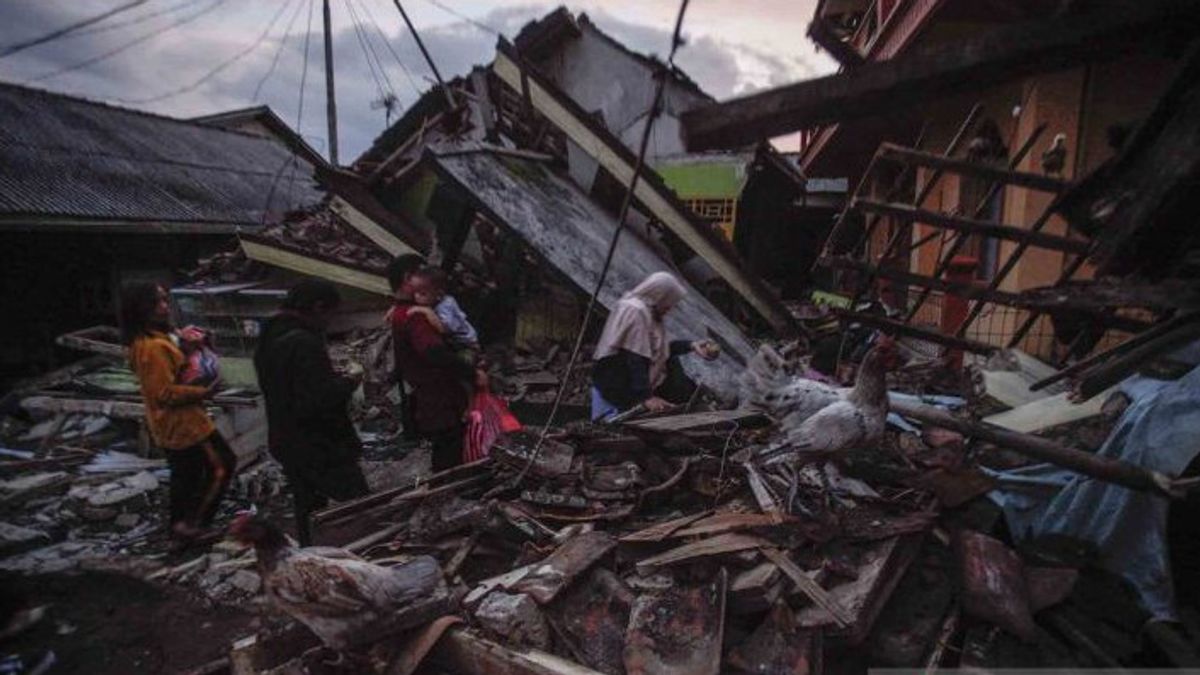


JAKARTA - An earthquake with a magnitude of 5.6 rocked Cianjur Regency on November 21, 2022, at around 13.21 WIB. House buildings, schools, places of worship, were damaged. A number of roads were cut off due to land shifts or were buried by landslides.
Data from the Regional Disaster Management Agency (BPBD) as of November 22, 2022, stated that 22,198 houses were damaged, 12,641 of which suffered heavy damage, resulting in 58,362 people being forced to evacuate.
Meanwhile, 1,351 people were recorded, 268 died and 183 were injured. BPBD also believes there are 151 people still being searched.
"The worst conditions are in Cianjur District, Cugenang District, and Pacet District. Meanwhile, the area on the south side is relatively safe," said Cianjur Regent Herman Suherman to reporters on November 21.
Although on a moderate scale, the Meteorology, Climatology and Geophysics Agency (BMKG) reported that the epicenter occurred on land with a depth of 10 km southwest of Cianjur Regency. More specifically, the coordinates are 6.84 south latitudes of 107.05 east longitude.
"So, the vibrations are felt very much even to Jabodetabek," said the Head of BMKG, Dwikorita Karnawati.
Dwikorita reminded residents to remain vigilant. Don't force yourself back to a house that is damaged or cracked. Because, until Tuesday (22/11) at 17.00 WIB alone there have been 145 aftershocks with a tremor of 1.5-4.2 magnitudes. It is possible that it will continue to occur in the next four days.
Residents who live on hilly slopes, valleys, or riverbanks must also be aware of landslides and flash floods after the earthquake.
The possibility of hilly slopes in Cianjur becomes fragile after the earthquake. These fragile slopes coupled with heavy rains can trigger landslides and flash floods by carrying slope-collapse materials. So the community and the local government also need to be aware of the dangers of participating after yesterday's earthquake," explained Dwikorita in a virtual statement, Tuesday (22/11).
The Governor of West Java, Ridwan Kamil, instructed the victims of the Cianjur earthquake to receive maximum care.
"Don't let any injured residents be left on the side of the road. So that they can get treatment at the hospital. This needs to be regulated," said Ridwan Kamil in a written statement, Tuesday (22/11).
"If indeed due to the limitations of hospitals in Cianjur it is not possible because the number of injuries is too large, I have coordinated with hospitals in Sukabumi, Bandung, and Cimahi to be able to handle it," said Ridwan Kamil.
In addition, Ridwan Kamil admitted that he had instructed to build an emergency hospital in the Cianjur Regency Hall area. "We have also coordinated with a number of agencies to procure public kitchens and evacuation tents."
BMKG has confirmed that the Cianjur earthquake occurred most likely due to the movement in Patan Cimandiri. This is because this fault is classified as very active and its movement has caused earthquakes several times.
Among other things, according to the journal Muhammad Adis SW, Gadjah Mada University student, Pelabuhan Ratu earthquake (1900), Cibadak earthquake (1973), Gandasoli earthquake (1982), Padalarang earthquake (1910), Tanjungsari earthquake (1972), Conggeang earthquake (1948), and Sukabumi earthquake (2001).
The Cimandiri break is located in the western part of West Java province. BASED starting from the mouth of the Cimandiri River at Pelabuhan Ratu, Sukabumi Regency and then heading northeast through Cianjur Regency, West Bandung Regency, and Subang Regency.
Patan had a meeting with Patan Lembang in the Padalarang area and a meeting with Patan Baribis in Subang. As an active fault, Patan Cimandiri moves at a sliding speed of 4-6 mm per year.
"Cimandiri is actually the most active fault among other existing faults. We in Bandung often feel an earthquake, always its location due to releasing energy activity in Patan Cimandiri," said Chairman of the Indonesian Disaster Expert Association (IABI) Dr. Ir. Harkunti P. Rahayu to VOI, Tuesday (22/11).
"I also turned out that the impact was quite massive. In fact, the scale is moderate, still relatively moderate even though the epicenter occurred on land," added Harkunti.
At least, it can be a study to anticipate similar incidents. However, Indonesia is geographically located in the Pacific Fire Circle area. The meeting place for three world tectonic plates such as the Indo-Australian Plate, Eurasian Plate, and Pacific Plate.
According to Harkunti, the plates continue to move, not infrequently giving rise to new faults. Not to mention, the existence of a number of active volcanoes. This is why Indonesia is often said to be an earthquake-prone area.
With these conditions, like it or not, the Indonesian people must make peace with the earthquake. What must be understood together is that spatial planning is not allowed to construct buildings along the fault line. Several kilometers on the right and left sides of the line must be empty.
"However, the problem is that earthquakes are difficult to predict and do not only occur in the fault line. So, the corridor is a bit difficult to implement," said Harkunti.
One definite way is to require the rules for the safety of earthquake-resistant buildings, especially buildings located on the line or around the fault line. So, if an earthquake occurs, the number of victims can be minimized.
The victim was injured or died generally because of a building. The earthquake did not kill people. If the condition of the building is sturdy, I think the potential for casualties can also be suppressed. This is very important," he added.
Head of the BMKG Earthquake and Tsunami Center, Daryonopun, said that the Sukabumi, Cianjur, Lembang, Purwakarta, Bandung areas are tectonically active and complex seismic areas that make the area prone to earthquakes.
"It is called an active seismic, because the results of BMKG monitors in the area often occur with various variations and depths," he said.
Regarding complexity, he continued, the area is an active earthquake lane area such as the presence of faults or faults in Cimandiri, Padalarang, Lembang, Cirata, and many other minor faults in the region. "So, the area became an earthquake area permanently," he said.
BMKG noted that there have been 14 earthquakes in the Cianjur-Sukabumi area with the potential for major damage. Among others in 1879, 1900, 1910, 1912, 1969, 1973, 1982, and 2001. Then, in 2011, 2012, and 2020.
The English, Chinese, Japanese, Arabic, and French versions are automatically generated by the AI. So there may still be inaccuracies in translating, please always see Indonesian as our main language. (system supported by DigitalSiber.id)


Related News