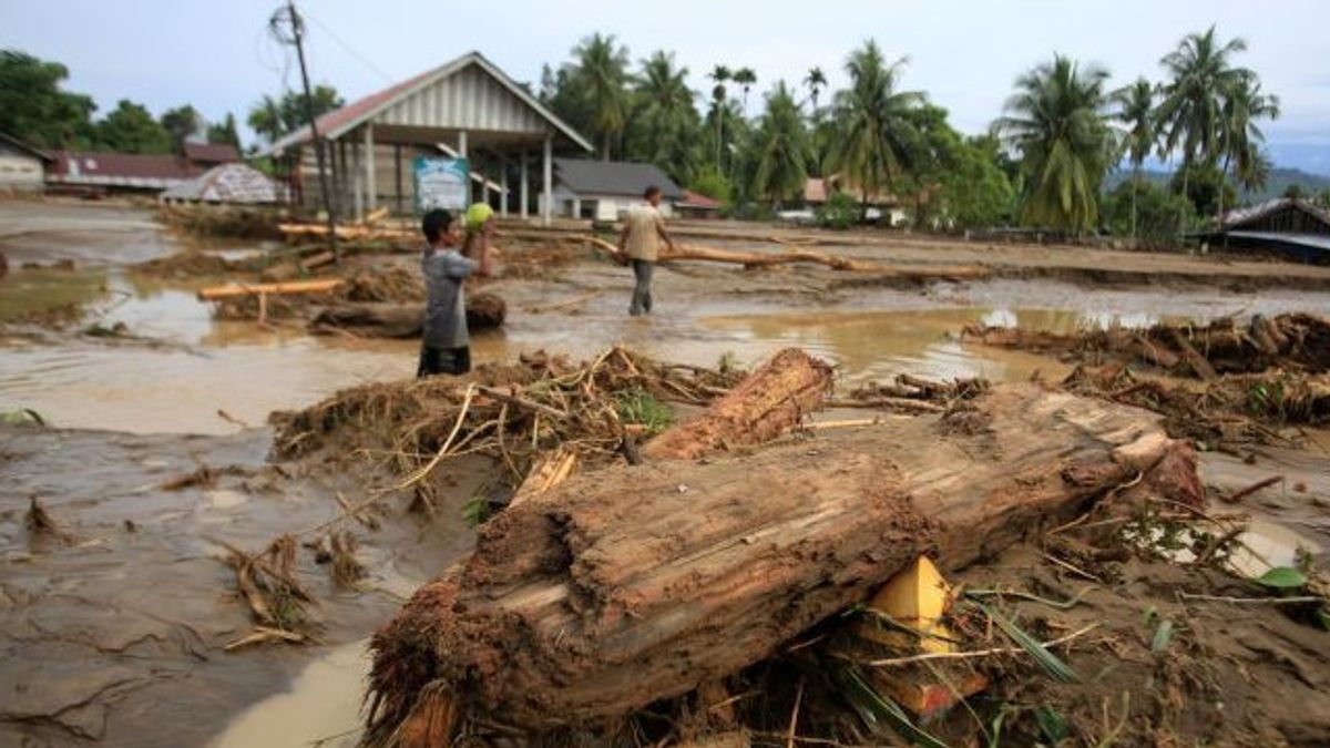


JAKARTA - PT Agincourt Resources (PTAR), the manager of Martabe Gold Mine, emphasized that the flash flood and landslide disaster in Garoga Village, Batang Toru Subdistrict, South Tapanuli, was triggered by extreme rainfall produced by Cyclone Senyar, not mining activities. The company considered it important to straighten out public information because news emerged linking the disaster to mining operations. In its statement, PTAR conveyed deep sorrow to the victims and affected families. Affixed with prayers for the victims and families, as well as the entire community affected by this event,'' wrote PTAR in a written message received by VOI, Thursday, December 4, 2025. The company presented a technical study based on field data, which showed that rain with very heavy intensity due to Cyclone Senyar became the main factor of the disaster. PTAR said that the rainfall was one of the most extreme in the last 50 years, and flushed the South Tapanuli region including the Batang Toru Forest area, which became the upstream of a number of rivers in Batang Toru District such as Aek Garoga, Aek Pahu, and Batang Toru River. In the context of hydrology, PTAR emphasized that the mine operational location was located in the Aek Pahu sub-watershed, while the starting point of the disaster was in sub-watershed Garoga. Although both rivers met in the downstream, the water system in the two watersheds was different so that PTAR activities were not related to flooding in Garoga.
SEE ALSO:
-
 | EKONOMI
Agincourt Resources Bantah Jadi Biang Kerok Banjir Bandang Sumatera Utara
03 Desember 2025, 12:52 -
 | BERITA
Pusdalops Catat 646 Warga Sumut di 4 Kabupaten Luka-luka Terdampak Bencana
04 Desember 2025, 15:31 -
 | EKONOMI
Kementerian ESDM Tepis Isu Tambang Martabe jadi Biang Kerok Banjir Bandang Sumut
02 Desember 2025, 11:24
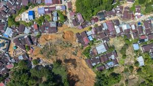
Companies detailed, the epicenter of the disaster occurred in Garoga Village before then spreading to other villages such as Huta Godang, Batu Horing, and Aek Ngadol Sitinjadi. Flash floods occurred because the river flow was unable to accommodate the very large water mass rate and was triggered by the blockage of logistic wood material on the Garoga I Bridge and Anggoli Bridge. The bridge triggered a sudden change in the river flow on November 25 at around 10.00 WIB so that two Garoga River tributaries merged into one large current that hit the settlement. Meanwhile, PTAR explained that although there were several avalanche points in the Aek Pahu sub-waterfall, the region did not experience flash floods. No mud or intensive logs were found as happened in the Garoga River. In fact, 15 mining girth villages around the Aek Pahu watershed did not experience any significant impact and are currently being displaced. Air observations using helicopters in the upstream area of the Garoga River show avalanche spots on the cliffs of the area. The avalanche was suspected to be a source of mud material as well as logs that were then carried away by the current into the river. However, PTAR confirmed that the findings were still initial indications and required follow-up studies to ensure the entire source of the disaster. Since the first day of the incident, PTAR was involved as part of the first responder through search and rescue activities (SAR), access opening, to establishing a complete evacuation post with emergency tents, public kitchens, and community clinics. Togethering with the local government, TNI-Polri, and other stakeholders, PTAR continues to mobilize all the resources it has to ease the burden of its beloved brothers,''' write the company. PTAR affirms its commitment to environmental compliance and calls Martabe's Gold Mining operations entirely located in the Area Status of Other Use (APL). The company also expressed support for the protection of biodiversity and environmental management in cooperation in collaboration with both national and international institutions. In its cover, PTAR invites all parties to maintain information accuracy, especially in the midst of disaster situations. We invite all parties to promote collaboration, communication, and good information management... We fully support comprehensive and independent studies to produce a firm company'
Previously, it was reported that the Coordinator of the Mining Advocacy Network (Jatam) Melky Nahar assessed that Sumatra had been treated as a sacrificial zone for mineral and coal mining (minerba).
There are at least 1,907 active mineral and coal mining business permit areas with a total area of 2,458,469.09 hectares.
"At the forest level, the Forest Area Use Approval (PPKH) scheme is the main door for the release of the protected function into an extraction room," he said.
Of these, 66 permits are allocated for mines with an area of 38,206.46 hectares, 11 permits for geothermal with an area of 436.92 hectares, 51 permits for oil and gas covering an area of 4,823.87 hectares, 72 permits for other energy projects with an area of 3,758.68 hectares, while the rest is given for telecommunications, government, and various other purposes.
PT Agincourt Resources (PTAR), the manager of the Martabe gold mine in the span of the Batang Toru Ecosystem, including one of the PPKH holders, "he said.
The English, Chinese, Japanese, Arabic, and French versions are automatically generated by the AI. So there may still be inaccuracies in translating, please always see Indonesian as our main language. (system supported by DigitalSiber.id)


