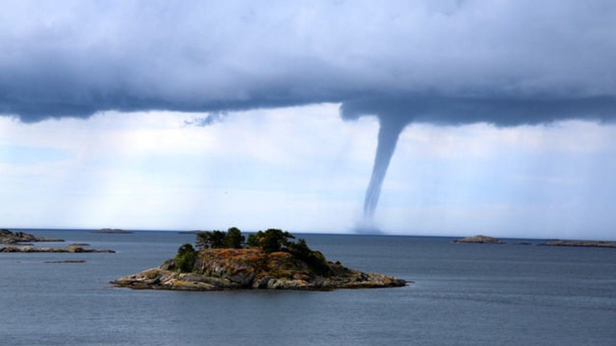


JAKARTA - The National Aeronautics and Space Agency (LAPAN) emphasized that the natural phenomenon that occurred in Wonogiri, East Java yesterday was not a tornado, but a water spout.
This natural phenomenon can be seen in the middle of Gajah Mungkur Reservoir, Wonogiri Regency, Central Java Province, on Wednesday, January 20, 2021 at around 15:45 WIB.
"There is a fundamental difference between the phenomenon of water spout and whirlwind due to weather anomalous conditions. The difference between water spout and tornado can be identified from its connection with the water medium found at the bottom," said LAPAN Center for Atmospheric Science and Technology (PSTA) researcher Erma. Yulihastin, in a statement on the official website of LAPAN, Thursday, January 21.
Erma explained, whirlwinds or tornadoes have wind speed and the impact of damage is below the Fujita-2 scale. Thus, the tornado has a trajectory of less than one kilometer with a life duration of under one hour.
Meanwhile, water spout is a tornado that is connected to water and has a micro (small) scale. This phenomenon, said Erma, can only occur on lakes, ponds, rivers, dams and other water surfaces.
Initially formed water spoutLAPAN divides the five phases of water spout formation. The first phase, there is support for temperature, humidity, and wind shifting. Second, a bright cloud phase forms above the water surface. The third phase, the bright cloud is surrounded by clouds around it which are dark gray.
The fourth phase, the formation of a light-colored funnel that is elongated and spiral-shaped. In the fifth phase, the longitudinal spiral funnel begins to appear by visual observation and on the surface of the water, water splashes are formed in all directions.
"During the fifth stage, water spout decay occurs when moist air or water vapor enters the storm funnel," said Erma.
A natural phenomenon in the form of water spout appears in the middle of the Mungkur Elephant reservoir, Kab. Wonogiri, Prov. Central Java, January 20, 2021 at around 15:45 WIB. LAPAN explains that there is a fundamental difference between the water spout phenomenon and a tornado due to anomalous weather conditions pic.twitter.com/iXtvEtK6A0
- LAPAN (@LAPAN_RI) January 21, 2021
Erma explained that the water spout can be visually recognized from its shape which is like a trunk or a long pipe funnel and is seen descending from a cumulus congestus or cumulonimbus type cloud.
"This incident is not only rare but also includes extreme weather because it describes a super cell storm at a micro space scale (tens of meters)," he said.
Water spouts are very rarely able to last long or even move from water to land. Because the water vapor support generated by a water surface tends to have unique characteristics, water spouts that have been formed in an area can potentially occur again in that area.
Furthermore, Erma said that the formation of cumulonimbus clouds can also trigger water spouts and tornadoes. This occurs due to a meeting or collision between two winds that have different characters or due to wind shear, this wind is then raised (updraft) and strengthened by the conditions of the surrounding air instability.
The English, Chinese, Japanese, Arabic, and French versions are automatically generated by the AI. So there may still be inaccuracies in translating, please always see Indonesian as our main language. (system supported by DigitalSiber.id)


Related News