

YOGYAKARTA - The Meteorology, Climatology and Geophysics Agency (BMKG) appealed to all marine service users to be aware of high waves to be very high in the southern seas of West Java, Central Java, and the Special Region of Yogyakarta on February 5, 2023.
"This high to very high wave is influenced by wind patterns in the southern part of Indonesia, which are dominantly moving from west to northwest at a speed of 5-25 knots," said Head of the BMKG Technician Group at the Tunggul Wulung Meteorological Station in Cilacap Teguh Wardoyo in Cilacap, Central Java, Antara, Sunday, February 5.
In this case, he said, wind movement patterns that tend to be in the same direction as high speeds can increase sea wave heights.
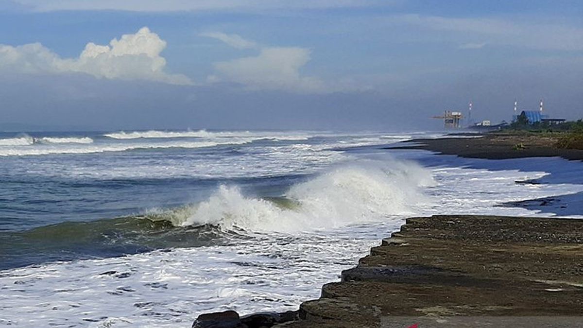
Areas that have the potential for high waves with heights ranging from 2.5-4 meters include the southern waters of West Java, the southern waters of Central Java, and the southern waters of Yogyakarta.
Meanwhile, areas that have the potential for very high waves with heights ranging from 4-6 meters include the Indian Ocean south of West Java, the Indian Ocean south of Central Java, and the Indian Ocean south of Yogyakarta.
Regarding this condition, Teguh appealed to all marine service users to pay attention to the high risk of waves to shipping safety, because based on analysis, wind speed is more than 15 knots and wave height above 1.25 meters is at risk for fishing boats.
Furthermore, wind speeds of more than 16 knots and wave heights above 1.5 meters are at risk of barges, wind speeds of more than 21 knots, and wave heights above 2.5 meters are at risk of ferries, as well as wind speeds of more than 27 knots and wave heights above 4 meters at risk for large ships, such as cargo ships and cruise ships.
He appealed to people who take advantage of the holiday momentum on weekends by traveling on the southern coast of West Java-DIY not to swim or play in the water, especially in coastal areas that are directly connected to the high seas, because high waves can come at any time.
"In general, the weather conditions in the southern sea of West Java-DIY on Sunday (5/2) are predicted to have the potential for light rain. We will immediately inform all marine service users if there are further developments related to the sea wave height south of West Java-DIY," said Teguh.
Asked about weather conditions in the Central Java region, he said extreme weather still has the potential to occur in a number of areas from Sunday to Monday because based on the results of atmospheric dynamics analysis, there is the potential for increased rain cloud growth and significant weather in parts of Indonesia, especially Central Java.
According to him, the potential for extreme weather is supported by several factors, including the Made Jullian Oscillation (MJO) phenomenon which is monitored to be active, especially on the west side of Indonesia.
In addition, he said, the Rossby Ekuator wave was observed to be active in the southern part of Java and the convergence in the Central Java region which was supported by relatively high humidity and unstable local lability.
"Based on these conditions, rain with moderate to heavy intensity which can be accompanied by lightning and strong winds still has the potential to occur in a number of areas on February 5-6, 2023," he said.
He said areas that have the potential for extreme weather on Sunday (5/6) include Cilacap, Banyumas, Purbalingga, Banjarnegara, Temanggung, Wonosobo, Kendal, Magelang Regency/City, Salatiga, Boyolali, Klaten, Semarang Regency, Brebes, Tegal Regency/City, Blora, Pati, Jepara, and surrounding areas.
Meanwhile, on Monday (6/2), extreme weather has the potential to occur in Cilacap, Brebes, Tegal Regency/City, Pemalang, Batang, Kendal, Magelang Regency/City, Klaten, Boyolali, Sragen, Jepara, and surrounding areas.
"We urge the public to remain alert to extreme weather that has the potential to cause hydrometeorological disasters in the form of floods, flash floods, landslides, strong winds, and tornadoes," said Teguh.
The English, Chinese, Japanese, Arabic, and French versions are automatically generated by the AI. So there may still be inaccuracies in translating, please always see Indonesian as our main language. (system supported by DigitalSiber.id)